Monday, May 5, 2025

2025 5th May Day 37 Kirkwall to Shapensay.

A very short hop, mainly to avoid another days marina charges.

Elwick Bay on the southern side of Shapensay had good shelter from the wind and there are two free moorings. I was warned that the shelter from waves is not too good in a south-westerly due to refracted waves, I am getting quite a lot of that with a north-westerly and it is not particularly comfortable, and making the spag bol for dinner will be a trial, but the wind is forecast to moderate significantly as it backs to westerly over night.

There was not much point in going further north as it would just mean a later start tomorrow to catch a favourable tide into the Sound of Faray. Hopefully I’ll make Otterswick on the north side of Sanday tomorrow and Grutness, Shetland, or a bit further on Wednesday, I suspect motoring will be required but neap tides and light winds should calm the seas a little.

When the sun is out it’s actually feeling quite warm now when out of the wind (all of 50F) different to the last few days and especially nights when I have been using two sleeping bags to keep warm.

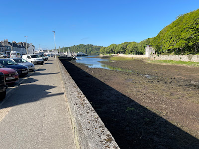
Leaving Kirkwall; it was a very short hop but I
did get to sail all of the way once out of the marina.
And I lucked out with the mooring, there was one
available and when I went up to it for a reccy the wind
dropped a bit from the 20 knts it had been and I 
grabbed the boat hook and the opportunity and 
got the pic up easily and first time.
It must have looked very professional from the shore 😄
I knew I had seen the anchored boat before on this
trip but could not place it. Then I remembered it
was in Kirkwall marina, and went back there after
a brief stay.

Photos when I get a better internet connection.

Just 4 miles in an hour and a quarter.

Thursday, May 1, 2025

2025 30th April Days 33 - ?, Kirkwall.

WIP

A lovely morning on Wednesday and a quick motor with the tide down to Kirkwall, in the afternoon it was even warm enough for me to ditch the thermally lined trousers and winter shirt in favour of summer attire for a couple of hours and I was feeling a bit down for not having left for Shetland but as I posted on FB there is an old aviation saying:

"Its better to be on the ground wishing you were in the air
than in the air wishing you were on the ground."

As I write this on Thursday I am feeling much better about it as it is cold and I'm being bumped around a bit in the marina, the shelter is rather better than I feared from looking at the chart and I took the trouble to turn round to face west and to lay on the north side of the E - W pontoon so am being blown off and the main hatch is to leeward, although its been closed today.

Wind gusts @13:00: Orkney 31 knts, Fair Isle: 29 Knts Shetland 33 knts.

Approaching Kirkwall


Orkney is very dependant on the cruise ships but it does result in
busy streets and lots of touristy based shops although how some
of them make a living in a few months of the year I don't know.
14.4 miles in 3 hours.

Update Friday

If this mornings models are correct I should be able to move out of the marina on Sunday or Monday and head for Shetland on Monday or Tuesday. 

Update Saturday

The wind is now round to the north 20 gusting 30++ I should be able to leave the marina when the wind goes round to the west on Monday and move north on Monday or Tuesday ready for the off. Ironically with light winds forecast for Tuesday and Wednesday it may be best to wait for a nice southerly forecast by some models for Thursday but with the high pressure area slow moving and close by it’s anyone’s guess what will actually happen that far out, or even on the day. 

My 2 favoured models for Tuesday lunch time

Click for Shapensay.

2025 29th April Day 31, To Fersness Bay, Eday.

Draft WIP

 After arriving at Gairsay I did some serious work with the pilot, the tidal atlas within it (much more detailed than the official Admiralty on) and notes from the Orkney marina's web site. The latter are very good but densely written without chart-lets, I found myself doing what I have criticised others for doing - flipping backwards and forwards on the iPad trying to orientate myself and identify places, once I realised what I was doing out came the paper chart and things became much clearer.

I had intended to leave for Shetland from the nearest sensible point, Otterswick, Sanday. I could not get there by a sensible time for an early start next day, but worked out that with the tide next morning my intended intermediate stop off at Fersness Bay, Eday would make a leg from there to an anchorage in the south of Shetland viable also that I could get to Fersness Bay at a sensible time leaving at about 16:00 to catch the first of the northerly flowing tide into the Sound of Farray, which only runs for about 4 hours.

Going another twenty odd miles direct to Lerwick would be a stretch and I would be arriving to an unfamiliar harbour at night or at dawn if I was lucky or used the engine a lot, so I discounted that option.

The latest forecasts were sort of encouraging so at 15:50 I was on my way again, into the Westray Firth for a very quick ride north.

With 4 - 5, occasionally more knots of tide, even making 5 through
 the water I was going crabwise for much of the way.
Into Westray Firth before the stronger tide and disturbed water.

A little later and to stay sailing might well have
let me be swept past my destination as the boat
was swinging wildly in the eddies and loosing power
as the sales alternately flapped in the breeze or were
were sheeted in far too tight. Fortunately there was no
swell coming down the Firth, if it had it would be
quite a long diversion or a dash to a safe haven.

Approaching the entrance to the Sound of Farry, just 
as tide turned to run into it. Fortunately close to shore
the tide was significantly less and quite calm. The
fish farming support ship following me probably 
was timing his run as I was. He passed close behind
as I turned into the bay.

The anchorage, rather nice in these conditions but 
exposed to the north.

I should have used a polarising filter on
the camera but forgot I had one with me until
later, but if you look carefully you can see
the chain out 20m or so.
The water was lovely and clear, I could see through more than 6m of water to plant the anchor between the scatted weed and see the chain on the sea bed way out, certainly 20m and with polarized glasses I am fairly sure I could see the anchor 30m away. 

I got some dinner on the go and checked the forecast. Not good:
24 hour forecast [from 19:00]: Variable, becoming south 2 to 4, increasing 5 or 6 later. Slight or moderate. Rain or drizzle with fog patches, showers later. Moderate or good, occasionally very poor.
I might have lived with that but the models I later downloaded had very strong winds, >30 knots, arriving Thursday mid day ish, (later gusting 40) that could catch me out on the final bit to Lerwick. 

I contemplated wating for the midnight forecast but decided not to as I would not get the detailed models until the tide had turned foul in the Sound of Farray. So I had to work out when I could leave for Kirkwall, fortunately that was easy and the best start was just before eight so I could have a lie in.
Stromness to Gairsay: 32 miles in six hours.
Gairsay to Eday: 10 miles in 2 hours.

2025 29th April Day 31, heading north.

DRAFT WIP

I had intended to stay at Stromness for 2 nights to get laundry done, resupply etc., but despite an outside chance of a weather window for Shetland opening on Monday I was tired after the last few days, particularly the lost nights sleep in Loch a'Chadh-fi on Thursday, and with the necessity of an 03:30 alarm call to make the tide on Sunday morning I decided to stay another night and thought it would then be a leisurely few days around the northern Islands mainly sheltering from some serious wind on its way.

However the model downloads at 20:00 on Monday night looked encouraging for Wednesday but could I get to a sensible starting point in time? My previous research only covered options staring from Kirkwall with a couple of stops before heading out, so I had a busy hour or so checking things out. It is quite complicated (I may do a post later on some of the issues) and I needed to get to bed for an early alarm call, I did however determine that going to Pierowall in the NW, an obvious candidate and one others have used, was probably just out of reach. If I had pushed the boat hard under engine I would probably reach Papa Sound just as the tide turned foul and with a particulalry high spring tide I might well not make it through in time and be stuck at sea.

I therefore decided to head towards Kirkwall but to stop short and check further options that might open up as the tide turned north westwards later in the day, providing I did not procrastinate I would still have time to take the last of the flood south to Kirkwall.

I slipped at 05:15 in dull overcast, chilly weather.

Entering Hoy Sound about 3 minutes late - 27 mins
of west going tide remaining, after the Rost will
have subsided.
Leaving Hoy Mouth.
The hour from Hoy Mouth was seriously uncomfortable with a nasty sea on the beam making the boat roll and sailing not practical, I was making 2 knots in 12 knots of wind as the rolling took the power out of the sail and the boat used all its energy going up and down. So on went the engine. The second hour was somewhat better but no wind 😣 I started to sail off Brough Head in a decent sailing beaze, albeit gusty, that was likely to get worse as I went up Eynhallow Sound and anyway the wind was dropping again and sailing through the overfalls, where on a west going tide the infamous Burgar Rost forms, did not seem like a good idea. Back motoring again.

Eynhallow Sound just SE of Eynhallow Island. 
Videos best played at half speed.
The anchorage, Millburn Bay, Gairsay.

Stromness to Millburn Bay, Eday.
32 miles in 6 hours.