Thursday, April 29, 2021

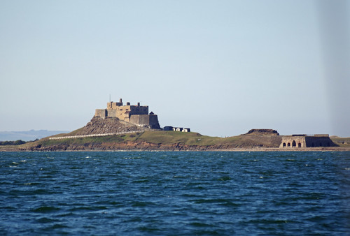
2021 Round GB Day 15. Ashore on Holy Island (Briefly).

I decided lunch ashore might be a good idea, unfortunately rain intervened, also it was cold and quite busy, certainly enough to overwhelm the local hostelries under Covid-19 rules so I came back after a brief visit. I had decided not to bother putting the outboard on the dinghy as the tide would be with me both ways, although going in was a fair pull because of the wind.

Achilles 9 metres Sancerre at Lindisfarne
Sancerre in the distance from the landing place.

Achilles 9 metres Sancerre at Lindisfarne
The anchorage.

The Abbey.

2021 Lindisfarne

Wednesday, April 28, 2021

2021 Round GB. Day 13/14 - Anchor Watch

Tuesday bought stronger than expected winds from the east which caused problems in the anchorage which is fairly exposed to wind from that direction, especially at high tide when guarding reefs and sand banks are covered. This was not an issue as the tide was coming in as the wind and tide were coming from the same direction, As soon as the tide changed things became difficult, the strong (2 knot) tide in the anchorage tried to hold the boat heading to the west but the wind which was now 20 knots with gusts above was pushing the boat into the tide often overcoming it causing the boat to push over the anchor then swing round, this was exacerbated by waves, not that big but steep and close together, caused by the wind over tide.  

The boats position over 24 hours from Tuesday morning. The anchor
symbol is the approximate position of the anchor after adjustment
during the evening, its in about 6 metres of water at low tide and
about 11 meters at high tide (we are one day off a spring tide).
The anchor was on the end of just under 50 metres of chain. The
circle is the guard area, if the boat goes out of it an alarm sounds - I
had the software running on two devices, with different limits to be sure.

The dense plots to the left of the plot above show the boats position before the wind arrived and the tide changed and the boat was stable. When the tide changed at about 16:00 things started to get wild with the boat swinging all over the place, exacerbated by the tide being slightly stronger to the south (bottom of the plot) than to the north, after an hour or so of these gyrations the anchor could be heard grumbling, probably being literally screwed out of the sea bed which at least in the shallower water, appears to be relatively thin sand and mud over rock.

With rain showers and strong winds I was suited up ready to go outside and had an early dinner. It was not long before it was necessary to take some action and I motored hard astern to reset the anchor and I expected to be on "anchor watch" until low tide at 22:00, monitoring the situation and making small adjustments to the rudder (otherwise locked in position) to try and keep the bow from riding over the anchor chain causing damage.

Fortunately at about 20:00 the wind backed round to the north east and everything calmed down a little. On the right of the plot the dense areas SE and NW of the anchor symbol are the boats position after things calmed during the flood and ebb tides respectively. 

Now, 10:15 on Wednesday, the wind is about NE at 15 knots, the sea calm and boat is stable and comfortable which is just as well as, if the wind is as forecast, I am likely to be here until Friday morning before heading off to Peterhead.

Click here for Day 15, ashore on Lindisfarne.

Monday, April 26, 2021

2021 Round GB Days 11 - ? Blyth to Lindisfarne.

The forecast was rather more moderate on Sunday morning, strong winds are still forecast for the coming week but not until Monday/Tuesday and not as strong as in previous forecasts, so the Lindisfarne anchorage should be tenable. 

Despite missing the tide waiting for the up-to-date weather maps I decided to press on with a forecast of reasonable winds to get there, that did not come to pass as winds were light and did not exceed 7 knots all day and was generally around 4 knots until a mile or so out when it picked up to a good sailing breeze and all that did was create more disturbed water as I went over the bar going into the lagoon at Lindisfarne. 

The fine weather did bring the opportunity of some sight seeing, rather different to last year when going in the opposite direction I passed the interesting bits in thick fog. 

Dunstanburgh Castle
Seahouses with Bamburgh Castle in the distance.
Seahouse
Inner Farne
Bamburgh Castle
The leading marks into Lindisfarne, you carry on on this heading
until the marks come into line then quickly turn left keeping them
in line until another set of marks (the church and a purpose built
tower) come into line, turn hard right and follow them into anchorage
through the narrow channel.
The view on the way in.
Looking out of the anchorage with the Farne Islands in the distance.
Looking up the anchorage towards the lagoon. A fellow solo
sailor at anchor, one of the few yachts I have seen so far.
This picture and the one above was taken at low tide, as I write
 the current here is 2 knots and about 4 knots in the narrowest
part of the channel.
The forecast on Monday morning was iffy, although the weather maps looked better but I decided not to risk starting the long trip to Peterhead, I could be here for a while.

Update: That turned out to be a good call, the evening inshore waters forecast indicated F7 on occasion.

Slide show all of my pictures around Lindisfarne, page through by clicking the arrows or click in the centre of the pic to view from Flickr in a new window or full screen:

2021 Lindisfarne

2021 Round GB Day 10. Filey - Blyth.


A great, albeit chilly, sail. after clearing Filey Brig I was able to sail all the way to Blyth offing at good speed. The dampener on this was the possibility of getting stuck in Blyth for an extended period due to approaching weather, hopefully not for 12 days as happened last year.

Click here for Day 11, Blyth to Lindisfarne.

72.4 NM in 14.5 hours an average of 4.99 knots. Wind generally easterly at 7 - 12 knots.

2021 Round GB Days 8 & 9. Lowestoft - Filey

This was a long cold trip, it started well at 06:30 and after clearing harbour and motoring to just past Great Yarmouth I had a good sail up the coast until 13:00 when I was east of Cromer, then the wind died and on went the engine and I had to keep it on for the rest of the afternoon before wind returned and I was able to sail through the night and into Filey arriving at 10:40 to anchor behind Filey Brig which was rather more comfortable than when I was there last year.

The night was the coldest sailing I can remember, and I have sailed in snow and washed ice and frost off of boats before sailing. I was wearing a fleece lined shirt, a Musto "Snug" windproof fleece, a thick padded Gilets and a premium offshore suit but the cold wind cut through everything and I was never warm.

Filey was a welcome sight, especially as some warm sun
was making me much more comfortable.
Filey Bay.

134 nautical miles over the ground in 28 hours. Winds variable 0 - 12 knots.

Slide show all of my pictures from Lowestoft to Filey, page through by clicking the arrows or click in the centre of the pic to view from Flickr in a new window or full screen:

2021 Lowestoft - Filey

Tuesday, April 20, 2021

2021 Round GB Days 5 - 7. Ramsgate to Lowestoft.

A cold and disappointing day, the inshore forecast indicated east to north east winds F3-4 which would have been fine but when I left it was west of north and by lunch time, when the updated forecast was still saying E - NE, it was still closer to north than north east. In the very constricted waters of the Thames Estuary that meant using the engine.

The Long Sands Two Way Route and surrounding waters.
The Thames Estuary has lots of sandbanks, windfarms and shipping routes, just off the screen shot above there is even a roundabout for shipping! In the centre of the shot is a narrow, 11 mile long, "2 way" route for small craft (boats less than 20 metres in length) each of the two lanes is less than a mile wide so beating up them against the wind is not really practical single handed with a big headsail - it would take forever and I would have been exhausted well before getting through.

To complicate matters on this trip there was fog, with visibility ranging from about a mile to half a mile for most of the morning with a few denser patches. 40 years ago without electronic aids the passage would have been very tense for the navigator finding the way and for the skipper and lookouts trying to avoid shipping, it would probably not be attempted if the fog was forecast, especially single handed.

Today things are much easier:

Sancerre's instruments are in the cockpit were I can see them.
Top left the chart plotter / multi function display, top right
the control for the autopilot displaying the boats head from
an electronic compass and below the VHF transceiver.

On the main instrument the left half of the screen is showing the chart, the boats position and planned track. The right half is showing the doppler radar output. Both sides include transponder returns from AIS (Automatic Identification System) equipped vessels which is mandatorily for all large ships, passenger vessels and is optional for small ones such as Sancerre, the little green mark on the radar screen west of Sancerre is one such return, IIRC a fishing boat. 

The sharp eyed with a big monitor might spot a bit of blue mixed with the green on the right hand section, that is the radar return. The yellow arrow on the left hand section indicates the direction of the tide, tapping on it will give the rate.

AIS shows the vessels position, track, speed etc. and the system automatically calculates a closest point of approach and will set off an alarm if that is within specified limits. The radar also has an alarm function and should show most vessels and is also useful for navigation, showing land, radar reflectors on buoys etc., but it does take practice to interpret. 

The area shaded red is the "guard zone" any radar return in the
area will trigger an alarm, unfortunately it frequently false alarms
so it is not that useful if you want to sleep. Pic from the next leg.
My back up, an iPad with GPS, a full set of Admiralty UK Charts
and a WiFi link to the AIS unit to show all AIS equipped vessels
in the area. Both pics taken at the southern end of the 2 Way route.

There is something about the "Sunk" Deep Water anchorage just north of the 2 Way route, this year as last my planned track went straight through a couple of anchored ships and I had to make detours.

The deep Water Anchorage in clearing fog, 6 hours into my trip.
Left to its own devices the auto pilot would have taken me
straight into the stern of the left hand ship.

I moored in front of this very expensive yacht, I was told that it
was impounded last week as it had 8 illegal immigrants on board,
presumably a luxury service. They were obviously trying to
 sneek them in (look carefully grinning face with smiling eyes).

74.6 nautical miles over the ground in 15 hours. Winds 5 - 11 knots on the nose.

Some bad weather is on the way with more cold north easterlies this time possibly F5-6 so I may be here fore a few days.

Click here for Days 8 & 9. Lowestoft - Filey.

Sunday, April 18, 2021

2021 Round GB Days 3 & 4. Rye to Ramsgate.

I woke at 03:00 to find the wind was west of North, a big improvement on NE so although the tide would be foul approaching Dover I moved out with the possibility of sailing to around the S Foreland rather than having to motor much of the way, Like the last, this cunning plan failed as the wind soon came round and became very variable in direction and from 6 or 7 knots up to 18 knots and later quite a bit more at times.


Once the tide turned, about half way from Dungeness to Dover, I was beating against the tide and with leeway I was being pushed 20 degrees off of the course steered so it was very slow going. A few miles short of Dover I moved very close to shore to get slack water from the early turn of the tide that is expected there. The wind suddenly increased from 10 to 20+ knots and veered 20+ degrees instantly, that was too much for the autopilot and I was flat aback. 

After sorting that out I was heading to shore and about half a mile off with the wind well over 20 knots so I tried to reef the headsail, but the roller reefing would not work, the problem was relatively easy to fix but not in such bad weather, in a rough sea and when heading towards the shore so the sail came down and on went the engine. 

With the sail down removing the control lines riding turn (caused by the  sail coming out too quickly when I started the day - a gust caught it and snatched the control line from my hand but in the dark I did not notice the riding turn) took about a minute but raising the sail again in those conditions which persisted all the way to Ramsgate (at F5) would have been hazardous and  in practical terms I would shortly need the engine to round the South Foreland and go up the Gull Stream directly into wind so the mainsail came down as well and I motored on to Ramsgate. The last few miles were in very rough conditions due to 20 knots of wind against 2 knots of tide in shallow water.

Passing Dover in a brief lull.
A rather dishevelled Sancerre on arrival. Big headsails, especially
less flexible relatively new ones, can be a problem single handed. 
Surprisingly the facilities are open so I'll stay over Sunday and leave for the North on Monday morning, looking at the forecasts that could be another frustrating day and there maybe some strong onshore winds coming on Thursday so I may get stuck in Lowestoft, or perhaps at anchor behind Spurn Point. we shall see.

55.1 nautical miles over the ground (far less if not beating and less still through the water going direct) in 14 hours. Winds 5 - 20+ knots.

Click here for Day 5, Ramsgate to Lowestoft.

2021 Round GB Day 2. Seaford to Rye

 A civilised start time of 8:30 and I was round Beachy Head by 9:45.

The "Seven Sisters", just west of Beachy Head.
Approaching Beachy Head
The inshore route around Beachy Head - not as intimidating
as Portland Bill but more impressive cliffs.
Approaching Eastbourne

Again winds were difficult and when I arrived off Rye the anchorage was very bumpy and I thought I would have to move closer in at 22:00 when the rising tide would permit, but that proved to be unnecessary. 

Seaford-Rye. Hard work with changing winds.

39.2 nautical miles over the ground in 9 hours. Winds 5 - 20 knots.

Slide show all of my pictures from Seaford to Rye, page through by clicking the arrows or click in the centre of the pic to view from Flickr in a new window or full screen:

2021 Seaford to Rye

Click here for Day 3, Rye to Ramsgate.

2021 Round GB Day 1. Hamble to Seaford.

Introduction

Posts on this trip may be written in real time or retrospectively so the tense will change, many will be cleaned up and additional pictures added when I get back and / or when stuck in harbour for a while.

If I am in one place for an extended period I may go back and update previous posts, add photos etc but the main proof reading, addition of photos and slide shows is normally done when I get home and have access to my main computer with its big screen, and some will wait until winter when there is little or no sailing to be enjoyed.

Charts are variously screen shots from:

  • SeaPro 3000 my general navigation program run on a laptop, connected to the boat systems but also with a u-blox76 GPS.
  • Garmin ActiveCaptain on an iPad which shares charts, tracks etc. with the Garmin plotter.
  • Admiralty or Antares charts displayed via the MemoryMap application on PC or iPad.
  • Marinetraffic.com.
Distances are in nautical miles (about 15% longer than statute miles) and usually "GPS" miles over the ground, distance through the water could be more or less depending on tides.

Day 1, Hamble to Seaford.

I was away at 03:30, on Thursday 15th April, leaving Deacon's Marina & Boatyard on the last of the flood which is the easiest and safest time to get out of a narrow berth which as other times has a strong current trying to knock you into other boats. It also gives a long favourable tide from the eastern Solent eastwards,

With the forecast wind the plan was to go North of the Rampion Wind farm so I went though the narrow Looe channel just off of Selsey Bill, that proved to be unfortunate as after a very pleasant albeit cold sail on a reach most of the way there, the wind freshened and I went through close hauled and into a very nasty sea caused by 15 - 19 knots of wind against 2 knots of tide in shallow water (5 metres at LAT (Lowest Astronomical Tide)) about 6 metres when I got there a day off of a spring tide.

Then the wind headed me again and it was clear I would not get north of the Rampion wind farm without tacking so I went to plan "B" and went south in the hope that the wind would revert. 

Approaching the Rampion Wind Farm, thoughtfully placed on the
direct line from Selsey Bill to Beachy Head - there will be
many more  to negotiate going up the east coast.

The "Cunning Plan" failed and once past the wind farm the wind veered further and it was a struggle to get to Seaford, just along the coast from Newhaven and about 7 miles NW of Beachy Head. But at least I did it all under sail once I was clear of the Hamble and Southampton Water.

Evidence that my cunning plan failed, not for the last time I suspect.

Seaford Anchorage, only useful in offshore winds
or unusually calm conditions,

67.9 nautical miles over the ground in 14 hours. Winds mainly c 12 knots but occasionally c 19 knots.

Click here for Day 2. Seaford to Rye.

Monday, April 12, 2021

The 2021 Season Round GB - here we go!

Finally. 

I didn't think I would make it when I went out to the car at 06:00 to find it was snowing - hard. Or when south of Newbury one of the idiots doing 70 or more crashed, fortunately I was less than half a mile behind and got through fairly quickly leaving behind a 5 mile queue. Fortunately the snow cleared north of Winchester and its been a decent day albeit cold. 

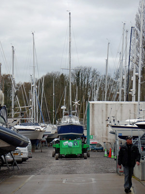
I put all of the gear, upholstery etc. on board and loaded up with stores, fuel and clothes whilst the boat was out of the water when I was finishing winter maintenance once Covid-19 restrictions allowed me to visit. It was a pain hoisting everything up but it saved several days when restrictions were lifted so I could stay on board allowing me to get away sooner.

The boat carrier is remote controlled.

Sancerre was launched by about 10:00, sails bent on, running rigging on and other work done by early evening. More work tomorrow, including running a cable up the mast for the wind instruments, then I'll take the car home returning by train and hopefully I will be on my way on Thursday. 

As last year the weather is not cooperating, then it was westerly gales when I was leaving to the west, this year it is east or N East winds, perhaps for a couple of weeks, that will make it difficult to get eastward then potentially limit anchorages when heading up the east coast, it's  Déjà vu all over again, but hopefully this time I'll not get stuck in harbour for 12 days as I did in Blyth last year.

Slide show of my launch pictures, page through by clicking the arrows or click in the centre of the pic to view from Flickr in a new window or full screen:

2021 Launch  

Click her for Day 1 to Seaford.