Wednesday, April 27, 2022

2022 St Kilda Day 33 To Tinkers Hole.

I left at 06:40 with an 8 knot easterly wind which was rather variable until about 10:00 when it settled down to ENE F3-4 when I was just off the norther point of Colonsay.

Off Colonsay heading to Tinker's Hole.
Entering "The Steamer Channel", a short cut to the Sound of Iona
Tinker's Hole is off to the right.
Tinker's Hole and the Steamer channel running west of Eilean
Dubh as sown on the excellent Antares Chart
Heading into Tinker's Hole, there is a sequence showing the
approach in the slide show below.
A rather tight anchorage if you want to stay out of the strong stream,
and out of the stream the slight tide is unpredictable, I was always south
of the anchor over about 14 hours. A line ashore to limit swing would
be a good idea and, in some locations essentially mandatory, especially
when it is busy, and it can get very busy!
Tinker's Hole is impressive and popular but I think there are
better options (and a couple of people I have spoken to agree),
perhaps an anchorage to go to once, or to take a look at. 
2022 St Kilda Day 33 To Tinker's Hole. 
26 miles in 7 hours.


2022 St Kilda Day 32 to Loch Tarbert, Bag Glean Righ Mor

I woke up well before the alarm but decided I might as well get moving so I was underway at 04:40, in the previous 30 minutes the wind had increased from virtually nothing to 14 knots so I was sailing immediately, 30 more minutes and it was blowing 25 knots and I was beating in to it and rather uncomfortable. 

McArthurs Head at the entrance to the Sound of Islay, between
Islay and Jura.

Struggling to beat up the sound the slight
changes of course N of the legend "Sound
of Islay" were actually tacks. 
As I approached the Sound of Islay the wind was down to F2 from the E, this set a bit of a pattern for the day with the wind constantly changing. 

To make the tide I used the engine for about 4 miles to McArthur's Head but I was then able to sail most of the way through the Sounds 11 mile length but after tacking back and forth with 1 - 3 knots of tide behind and the wind F4 varying quickly from east to north west. The wind was also gusty due to the mountains.

A very nasty sea built up as I approached the north end of the sound so I motored out.

I was heading for Loch Tarbert, I anchored on the south side in Glenbatric Bay in 2020 but with the wind from the north the north bank was a better option or a long way up the loch through some tricky Pilotage. 

Also I really wanted to see the raised beaches that line the loch but which I had been unable to check out previously due to time constrains and bad weather. These beaches were left stranded well above sea level as the land rebounded after being depressed by the ice ages.

On this occasion I had plenty of time, so the plan was to check out all of the anchorages up to and perhaps beyond Cumhann Mor the first very narrow passage.

The first anchorage I passed is quite open to swell but a useful stop off point waiting for a southbound tide through the Sound of Islay which one boat was doing. The second anchorage, Bag Glean Righ Mor, looked really nice, more of that later. It was high tide so I could take a few small liberties as I went further up, unfortunately struggling to take pictures in difficult conditions coming up the Sound I had accidently switched the camera to black and white mode, at some point I'll put those up as a slide show but it will take a while as there are a lot!

Multiple raised beaches in Loch Tarbert

My track up past the 3rd anchorage, nice but not as nice as the
second, and into the small pool at the top, very nice but with
limited room.
I turned round at Cumhann Mor, in the conditions and with the Antares charts and GPS going further would not be a problem but I might be leaving in the dark and at low water so decided to go back to the Bag Glean Righ Mor anchorage.
Raised beaches at Bag Glean Righ Mor.
Raised beaches at Bag Glean Righ Mor.
2022 St Kilda Day 32 Loch Tarbert 

Forty miles in eight and a quarter hours.

Thursday, April 21, 2022

2022 St Kilda Days 27 to 31 to Browns Bay and Islay

The forecast on Tuesday was promising:

Lough Foyle to Carlingford Lough

24 hour forecast: Variable 3 or less, becoming east or southeast 2 to 4 later. Moderate in far north, otherwise smooth or slight. Showers at first. Good.

Outlook for the following 24 hours: East or southeast 3 to 5. Slight or moderate at first in far north and later elsewhere, otherwise smooth or slight. Showers for a time. Good.

I left Bangor at lunch time as the tide turned northerly, it was rather slow at first but then the south-easterly set in early and it was a very pleasant sail to Browns Bay only using the engine for a total of 40 minutes to get out of the marina and to anchor. 

I would have liked to have done further north but the anchorages there are exposed to easterly winds.
Browns Bay
Looking north from Browns Bay, The Mull of Kintyre in the
distance.


15 miles in 4.5 hours.

The weather on Wednesday morning was lovely apart from a lack of wind which was a problem, the tide would be running south until after lunch at between 1.5 and 3 knots, with a light wind or even a F3 to 4 on a run I would likely be going backwards so I decided to use the engine until the tide turned then to head for a recommended anchorage on the south end of Gigha that has only recently been surveyed (by Antares) to sufficient detail to make it usable. This would also give me a nice reach to get to the Sound of Islay on Thursday.

The first part of the plan worked but the lunch time forecast put paid to Gigha with winds now forecast to be E or NE 3 -5 occasionally 6 and similar on Friday. A small anchorage with a complicated approach and possibly somewhat exposed would not be a good idea, so I opted for Port Ellen on Islay. As the tide turned a reasonable wind also set in, except in the lea of Kintyre, and I sailed all the way to Port Ellen.

Irrespective of the time I leave I always seem to encounter a 
ferry leaving Browns Bay and sometimes on arrival. This time close
enough that I stopped to keep clear although in theory I was the "stand
on vessel" it does not seem reasonable to insist for a few minutes delay.
Passing inside The Maidens N of Larne.
The Mull of Kintyre.
SV Sancerre
Evening at Port Ellen, most of the locals don't have their boats in
the water yet.
I am staying in Port Ellen on Thursday; Friday & Saturday will depend on the forecast but it may be Ok for an uncomfortable beat to the entrance to the Sound of Islay. 

43 miles in 11 hours.

2022 St Kilda Days 27 & 28 To Browns Bay and Islay

Update Friday 22nd.


The forecast seems to stay much the same with each update, this at lunch time.

Mull of Kintyre to Ardnamurchan Point - Strong wind warning

24 hour forecast: East or northeast 3 to 5, occasionally 6 later. Slight or moderate. Fair. Good.
Outlook for the following 24 hours: East or northeast 3 to 5, occasionally 6 at first. Smooth or slight, occasionally moderate in west. Fair. Good.

Bashing into a F5 or 6 up to the Sound of Islay and then anchoring In Loch Tarbert does not sound like fun, especially against the tide so if the wind drops sufficiently to easily get off of the pontoon I plan to move to the anchorage to save 2 days berthing charges and move off on Sunday when a not to early start will give me a some favourable tide to get to the Sound and still have sufficient time to get through before the tide turns.

Update Saturday: I got out of the marina last evening with no drama in a lull and moved to the anchorage. It was a good call not to leave today, I woke to the wind howling in the rigging and an uncomfortable roll on the boat, a while later when I turned on the anemometer it was blowing 30 knots decreasing to 20 knots over half an hour and it has been varying from 15 - 25 knots all morning. 

The lunchtime inshore waters forecast for tomorrow looks OK but is looking iffy on some models, at least in the morning, but if the models are right and it has dropped by mid-morning I'll probably move east and anchor for a few hours to take the evening tide up the Sound of Islay.

Slide show of pictures taken from the anchorage:
Port Ellen anchorage, Kilnaughton Bay

Monday, April 18, 2022

2022 St Kilda, Flooding and problems with the Wind generator.

I have had a couple of mechanical problems so far, neither expensive to fix but a pain never the less. 

The Failed Wind Generator.

Going in towards Milford Haven the generator stopped working, whilst anchored up river I went through the makers fault finding guide which showed that there was probably a break in the cable or a faulty connection. The connection at the regulator was fine so going any further was going to be a challenge, the generator comes with short leads and a piece of chocolate block that you put the main cable onto. The problem is the join is in the support tube so the very heavy unit has to be lifted off to get at it and the cable will have to be cut in the lazarette and pulled through the deck gland to allow the unit to be removed.

When I go to Bangor and had some rest I wrestled it down, as expected not an easy job, the cable join was fine, surprisingly in as good condition as when installed. I partially disassembled the unit and checked the connection between the cable and the output from the electronics and found there was no connection through the positive line. Taking the brush unit off the problem was revealed, a brush broken off at the base, perhaps caused by the rough sea when it failed.

Only one slip ring brush left.
Spares are available by post but I have decided to wait until I get home before doing the repair, I remember how difficult it was to put the unit in place and I don't think I can risk doing it without a ladder, also I need to find the broken piece and / or clear out all the debris from the unit which may need it to be taken to pieces which will be much easier on a bench finally having spares sent ahead to a harbour or marina I would have to commit to going to a specific place to pick it up and there always seems to be some delay (Newlyn for the starter motor and my spare prop getting to Stromness in 2020).

By removing a hatch cover I have found a secure stowage in
the fore peak that does not take up to much space.

Flooding

Written Monday the 18th.

This became a bit of a saga but briefly, when in Newlyn I found quite a lot of water in the lazarette, I had not noticed it when I put the fenders in leaving Portland but I could not be sure. I pumped it out and it stayed dry for the rest of the time there.

In Milford there was again a lot of water there, although I could not think how water gets there from forward the prime suspect was the recently repacked stern gland which sure enough needed tightening some more. So again I pumped out.

Going across to Ireland the bilge pump was going off fairly frequently so whilst sailing I went headfirst into the quarter berth to check the stern gland, It was not leaking and was still tight but there was a lot of water about and sure enough the lazarette had a lot of water (gallons) in it. I started up the engine and rechecked the stern gland, no water coming from it but water was coming down from above. 

Tracking back I found water coming from one of the water hoses, on the outlet side going to the anti-syphon valve between the engine and the exhaust elbow. Fortunately it is a generic hose so easily replaced. 

It would appear the water was getting aft by running down the exhaust pipe into the lazarette dropping off as the pipe goes up into the swans neck. Once in the lazarette there was no way back to the main bilge and the automatic pump. Some water went straight down then forward to the bilge. Parts of the engine was covered in salt and not easy to remove in places.

The leak was above the engine where the hose goes through a narrow gap between the engine and the engine box and it had been rubbing on the engine. To make a temporary fix at sea, I had to take front of the engine box to pieces and remove the drawer unit over. I then bandaged the hose up with conforming tape with electric tape over. That has held for the trip up the Irish coast, but I need to fix it properly before leaving Bangor.

Being Easter everything, including the chandler, is closed so it will be Tuesday before I can get some new hose, when I removed the leaking hose and the return which has a rub but not yet leaking, I found it was original (1997) 1/2" car heater hose so if the chandler does not have stock the large automotive spares outlet in town should have some. Fitting will hopefully be straightforward as I have access to both ends and access is relatively easy to route the chose so I am hoping to leave at lunch time tuesday.

I may add some pictures when the fix is done.

Update: Tuesday 19th.

No hose to be had in Bangor! However all was not lost, the anti-syphon valve was mounted on the inboard side of the cockpit locker in the middle of the hatch opening, I found that the two main pipes, but not the drain, would go through an existing hole into the engine compartment mainly used for cables, so I moved the valve c 18" forward to the front of the locker which with a more direct routing allowed me to cut the hoses shorter removing the damaged sections. The route is actually better avoiding some rub points and naturally pushing the hose up and away from the engine. The valve drain hose was fortunately long enough to go back to the original route to the engine bay although I would like it to go further down.

2022 St Kilda Days 24 & 26 to Bangor

As mentioned in the previous post I was now forced to do a long trip or stay where I was until the wind turned westerly, possibly a long time. The potential problem was getting around or behind Copeland Island to enter Belfast Loch, there are strong tides and extensive over-falls, especially to the east of the Island. Going through  the over-falls inside Copeland Island with a strong wind, forecast at the time to be S F3-5, and actually F4-5 occasionally 6, against several knots of tide did not appeal and that would mean a detour of 8 - 10 miles. According to the navigation software I could not make it before the tide turned without starting at midnight and probably motoring.

However, I knew something the navigation software did not, the tides are at best ill-defined for a long section of the route and that just might work for me.

The tidal atlas, a version of which the software uses, shows an extensive area of slack water on the route, this is caused where the flood tide coming around the south of Ireland meets the flood tide coming around the north. I know from experience that it is not really slack for all the hours shown over the whole area, it varies depending on a number of factors and is to an extent chaotic. There are tidal flows, but they are not susceptible to accurately forecasting them for the atlas. 

I therefore decided to leave at my now habitual 03:30 to take some of the flood northwards into the "slack area", with a strong southerly wind there was a good chance that the northerly flow would be stronger than normal and extend well into the slack area with the converse happening to the north. I should then pick up the north setting ebb on the other side and perhaps carry that to Copeland Island. It was going to be tight, but I just might make it or at least get through before the fiercest tide. If that failed I would be in for a long detour. One way or another I would go into Bangor marine for R&R and to fix my engine cooling problem.

sv sancerre
Heading north from The Skerries, it is 04:30 with a full moon.
The wind was very light but filled in slowly and by 05:20 I was sailing and making good speed with the wind mainly F5 with spells below and above. Good news!
This caused some confusion, having passed the entrance to
Strangford Loch I was looking for the South Rock Buoy that 
has an AIS beacon but all I could see on the bearing was a ship
it turned out to have the buoy on deck for maintenance and the
ships AIS signal was hidden by that from the buoy.
Donaghadee Harbour approaching the Donaghadee sound and
the passage inside Copeland Island.  
The passage inside Copeland Island and my track. Note the over-
falls at the southern end and then narrow channel between the
red (port hand) and green (starboard hand) buoys.
Despite my very quick passage, good boat speed and at no time having an adverse tide, it was a close run thing, as I passed Donaghadee I had 1.5 knots of tide behind me, at the first pair of buoys less than a knot and by the way point "S Copeland" (actualy SW of the island, click on the pic to see better) I had 1.5 knots against me, a complete reversal in less than half a mile. I then had to go against the tide another 1.5 miles, which was not difficult with a F6 behind me, before picking up the flow going into Belfast Loch.

70 miles over the ground in 14 hours 45 minuets (including the time taken mooring etc.).

2022 St Kilda Days 22 & 23 to Wicklow then The Skerries

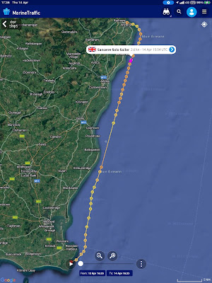
The tide again required an early start as it would for the next 3 days, this time I was away by 03:30.

St Margaret's Bay to Wicklow 
06:00, on a dead run in a F3 wind. At night the 10.5" iPad is
easier on the eye and on my back than the 7" screen low down
on the back of the cabin. It is less good in bright conditions.
Care is needed along this coast, there are strong currents waiting
to set you onto the offshore banks or to the shore.
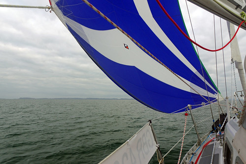
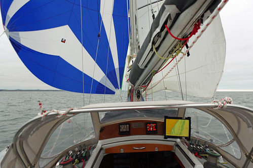
I started with just the genoa then added the cruising chute as the wind moderated and was making good progress, as the wind dropped further I changed to the spinnaker with mainsail.
 
I had the 60m symmetrical  spinnaker up for about 3 hours but
took it down when the wind got to 15 knots, on the almost dead
 run it was fine in that wind but I thought the gradual increase
would continue and I was right, 20 minutes later it was 20 knots.
I finished this leg under genoa only in F5 winds. St Margaret's Bay to Wicklow, 53 miles in 13 hours.

Wicklow harbour management does not get a good write up in the pilot and its not really suitable for yachts anyway but in reasonable conditions there is a decent anchorage just NW of the harbour close to the shore, the holding appears good and it was a comfortable night until the boat swung broadside to the small waves coming in around Wicklow Head but the roll was not excessive and in any case I had to get up and weighed at 03:40. heading for The Skerries. 

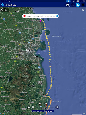
Wicklow to The Skerries.
I had planned to go round all of the Islands before heading west to the harbour but seeing a yacht motor out through them against the tide I did a quick check and just short of high tide there would be plenty of water to go inside one or both of the two outer Islands, the passage inside of the outer island is easier and about the same distance to the destination so I went that way sailing under the reefed headsail only 


Through the Skerries to the harbour.
There is no dedicated area for anchoring so you have to pick a spot between moorings that, at least in early April, were widely spaced. Near springs with a fin keeled boat you can't go too far in and I was a little worried about surge as I explored but I need not have worried, it must have been the wake of a boat because I had a restful afternoon and night, although the later was cut short by the need to leave early... again.
Picture from the anchorage on arrival.
Later in the afternoon the weather improved and it was quite pleasant.
The next planned stop was Ardglass in Northern Ireland and I tried to phone ahead to check likely availability of a berth but could not get through, then I checked the web site to find that the marina was closed to visitors until further notice due to work on the pontoon moorings. 

This was bad news as it was likely to be getting quite windy from the S or SE and the next all tide harbour or safe anchorage is 70 miles north in Belfast Loch and as will be explained in the next post there is a nasty tidal gate to take into consideration, a long day was in prospect.

40 miles over the ground in seven and a half hours.

2022 St Kilda Days 22 & 23 to Wicklow and The Skerries

2022 St Kilda Days 20 & 21 to Dale Bay then St Margaret's Bay IRE.

Milford Haven is long so to shorten the trip on Wednesday when the wind eased I moved to the anchorage at Dale Shelf on Tuesday afternoon, motoring till past most of the oil facilities then a pleasant but chilly sail, that turned into a bit of a theme on this trip.

10 miles in two and a half hours.

It was another early start on Wednesday, again a theme for this trip and not a welcome one, I was up at 02:30 to find a light mist but visibility not that bad, I could see the land around the bay and lights several miles away on the oil terminal. The fog horn at St Ann's Head was sounding not far away but was not really concerning given what I could see. 

I was away at 03:00, turned around Dale Point and into dense fog with visibility a few boat lengths. I didn't see any more land until approaching Ireland!  I was very close to land but had the comfort of some buoys, GPS and radar and made a point of closely following the track I had on the plotter from when I entered last year, a favourite ploy of mine.

Radar watch in fog at night is usually a strain and concentrating on a small screen you have to watch out for sea sickness which on this occasion I just avoided until a belated Stugeron kicked in. I had a bit of a scare passing south of Skokholm when the collision alarm went off as the Irish Ferry came from astern at high speed, fortunately due to the possibility of over-falls I was rather further out so she went past less than a mile away, unseen except on Radar and AIS - hopefully both ways!

Leaving Milford, once out of Dale the visibility varied from
a few boat lengths to perhaps half a mile on occasion until off
of this pic.
Crossing to Ireland
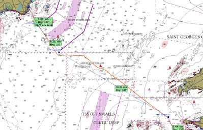
I had to remain under power until 08:20 when some wind set in and I was then able to sail in variable winds until I got to the SE corner of the Tuskar Traffic Separation Scheme (TSS) by which time the wind was light and on the nose so to avoid the TSS (you have to follow the direction of the lane or cross heading at right angles) the engine went back on until past then again for the final approach into St Margaret's Bay. 

There was some drama with flooding on the way over but I'll cover that saga in a separate post. Here.

61 miles in 13 hours. No pictures due to the fog and a lack of anything interesting at the Irish end.

Monday, April 11, 2022

Iridium tracking activated

Iridium satellite tracking is now active, starting at St Michaels Mount last Saturday and is available on the tracking page from the tab above.

2022 St Kilda Day 19 Near disaster then up the River Cleddau.

After a peaceful night in winds up to and perhaps above 30 knots I declined the opportunity to move to a mooring as it would be tricky getting onto a buoy single handed in 30 knots, especially as it does not have a pickup attached.

Less than an hour later I came closer to disaster than I have faced on a boat and that includes losing the rudder offshore, three times, after one of which we took a day and a half to get from the southern North Sea to Harwich. 

Fortunately I was standing by the cooker waiting for the kettle to boil when there was a violent lurch and the anchor alarm went off, being right by the hatch I had the washboards out and was on deck in record time, those few seconds may have saved me from going aground. 

As always when I am on board at anchor the key was in the ignition ready and the engine fired up immediately (changing the starter motor / solenoid whilst in Newlyn may have paid off!)  and I put the power on with the boat going backwards at a fair clip, healing well over in way more than 30 knots of wind and not really answering the helm with the drag of the anchor and chain.

The anchor alarm plot annotated.  the scale line at the top is 40 yards, a
little over 4 boat lengths. The wind was from the south east, 37 knots about
half way through the above and well over 40 knots at the start

The boat dragged 40 yards before the engine and anchor checked the boat, I was now very close to a mud bank off the starboard quarter and close to a navigation buoy on the port quarter.

I was then fighting to keep the boat moving into wind whilst trying to get the anchor up (using an electric windlass, I could not have got it up otherwise), the engine controls and tiller are aft and the anchor locker is right forward, it being shallow the chain has to be manually flaked as it comes in, so I was dashing back and forth. Getting the anchor up was sometimes stopped by the chain taking an acute angle around the stem fitting. I think I just brushed the mud bank (it was dead low tide), this time the sharp list away from the wind and reduced draft probably helped me avoid bumping harder.

Finally, although it was not long in time, I was in the deep channel, the anchor came  free and the autopilot was able to maintain a heading into wind as I got the anchor the rest of the way up. 

Things could still go wrong, the channel out is narrow and with the very strong wind - I saw 37 knots when as the wind eased I risked a few seconds below deck to switch on the instruments for the depth sounder, GPS map, autopilot and the VHF - just in case I had to call for help.

My track out.
Once out of the channel and the boat was stable under autopilot I got a warm gilet and waterproof top, the wet bottom half would have to wait. Motoring up the river was most likely to get me into shelter so I went that way, Nayland marina was an option, but I have not been there and it could be tricky single handed, at low tide and with the strong following wind. That was a good decision, a locally based sailor told me that in less wind that afternoon a friend who has been sailing from there for 20 + years was concerned about going in. 

There were lots of vacant (private) moorings but getting on one would be difficult in the still very strong wind and you never know if a mooring has been maintained or strong enough. So I went up the river past Cleddau Bridge and anchored on the southern side of the river after checking the depth over a reasonable area. The exposed banks (it was still close to low water) and the chart shows mud and gravel that should give good holding and the anchor held in the moderate wind with the engine running full astern so I should be OK.
From the new anchorage when things had quietened down,
Looking up river.
So in the end I got away with a paper chart ruined by a half cup of cold coffee that went flying, a lot of steam in the cabin, remember the kettle? and cold, wet feet and legs which a change of clothes and the new diesel heater fixed.

Edit after a question posted on Flickr: 

The problem was not my ground tackle: A 10Kg Lewmar Delta anchor (one size larger than recommended and acording to the makers good for a boat twice the weight of Sancerre and half as long again), all chain rode with plenty of scope - at this stage of the tide better than 8:1, and a Davis "Shockle" anchor snubber. The Delta has Lloyds certification as a high holding power anchor and I have ridden to it in worse conditions on several occasions. 

The problem was poor holding ground, I suspect recent dredging had left a hollow and I anchored just beyond it or a hump that I anchored on and under stress the anchor pulled further into the seabed but came out through the down slope from either.

Update Monday evening.

The tide tomorrow is not helpful especially as I could easily take 2 hours to reach the open sea, nor is the wind looking good, it might be onshore when reaching Ireland which could take a long time with variable winds. So with light winds, sometime tomorrow I am planning to move down the Haven to anchor as close as sensible to the open sea. That will gain me an hour and a half and with the tide an hour later I can leave at 03:30 or a bit later and have a favourable tide out past "The Smalls" and into St George's Channel.

Click here for the trip to Ireland.

2022 St Kilda Days 17 - 18 St Michaels Mount to Crow Pool, Milford Haven.

A trip of 3 or 4 parts. I had intended to leave about 14:00 to be at the Runnel Stone (see chart below), south of Lands End at 16:00 as the tide turned. It was however a very nice day with light winds so I thought I might as well be sailing so left at 12:00 after an early dinner.

Passing Mousehole (pronounced Mauzole or Mowzle)
The wind was rather variable but stabilised when I was off of Mousehole and I stood out to sea on starboard tack before tacking to make the Runnel Stone. Unfortunately the nice F3 wind died so on went the engine which stayed on for much longer than I was comfortable with, but it was necessary to maintain a reasonable speed if I was to get to Milford Haven before some strong winds that were forecast to arrive the following afternoon or evening.
The conservative planned track in blue. My actual track in red. In light
winds and a moderate swell I went rather closer in than planned after
passing the Runnel Stone a few minutes early.
Off Gwennap head, just past the Runnel Stone, Land's End (right)
and The Long Ships (centre). The ripples on the water was partly
a light wind, partly tide.
The Long Ships light with Cape Cornwall in the distance.

The very light winds persisted until almost midnight when the forecast south easterly set in and I was sailing from 23:45 initially at F3 but building to F4 then F5 around 05:00. The last few hours were very rough going with the wind at the top end of F5 with a few gusts of F6 but more serious was the very nasty quartering sea knocking the boat off coarse to an up wind broach before the autopilot could correct, 2 reefs in the main helped for a while but I ended up sailing for several hours with no main and a double reefed headsail and still making 5 - 6 knots. It is quite likely that this rough weather caused the failure of my wind generator which happen at this time, covered in this separate post (opens in new window).

I took a quick look at West Angle bay but decided against that as an anchorage and moved to Crow Pool just below Pembroke docks, a small pool at the bottom of the Pembroke River anchoring at 12:00, 138 Nautical miles over the ground in 24 hours.

2022 St Kilda Days 17 - 19 Milford Haven