Saturday, August 28, 2021

2021 Late Summer Cruise, Days 10 - 12, Hugh Town - St Helen's Pool.

Thursday was spent getting a shower, a brief wander around town, shopping and just "chilling out" listening to the test match commentary. On Friday I walked, very slowly, around the "garrison" area of St Mary's (pics below) built in stages from the 17th to 19th century with a few additions in 1900 and again during WWII.

The Garrison Area

The Garrison Area is west of the town of Hugh, the harbour is to the north of the town and Porth Cressa is to the south. At the top of the hill is an old "star" fort now redeveloped and extended as a hotel.


Slide show of my pictures in St Marys, page through by clicking the arrows or click in the centre of the pic to view from Flickr in a new window or full screen: 

2021 ST Marys

To St Helens Pool.

Sunday was an early start to ensure plenty of time to get to the other side of the islands and back again if the anchorages in St Helen's Pool and Old Grimsby were full or looked ropey. With lots of rocks and shallow water it makes sense to move about in the second half of the flood tide.

My track from Hugh Town to St Helen's Pool (red) and an exit
route through Crow Sound (blue). All the green areas dry at springs
(Lowest Astronomical Tide) and much dries on most tides. 

The route out of St Helen's Pool via
the "Gap"

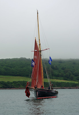
It was somewhat surprising to see many familiar boats around the islands, at least a dozen of them, some like "Marguerite" seen at Cawsand, St Mawes and again in St Helen's Pool were clearly just following the same route as me, but several I have seen on other cruises.

Tomorrow will be a 06:30 start to catch the tide back to the mainland. The start will likely be a bit tense, one option is to the north through "St Helen's Gap" with a navigable passage only 100 yards wide that is not marked and there are no transits, you just have to aim for just left of centre between two visible rooks some distance away. The advantage is that this leads straight to deep water and if the wind is from the NE quadrant it gives a better angle to the wind. 

The second option is to the east through Crow Sound going through a lot of shallow water, navigate through or around a tidal race / over-falls and potentially having to go more upwind once the engine goes off.

Fortunately these days GPS will make things much easier than in days gone by.

The tidal range here is not significantly higher than than many places in the channel, today when we are half way between springs and neaps it is 3.5 metres compared with 3.6m at Falmouth and 3.5m at Newlyn but is dwarfed by the 5.9m at Guernsey. What makes the tide so important is the large number of rocks, big and small and wide expanses that dry or almost so.

Achilles 9 metres "Sancerre" in St Helens Pool, Isles of Scilly
The view from St Helens Pool towards Old Grimsby taken
shortly before high water.
Achilles 9 metres "Sancerre" in St Helens Pool, Isles of Scilly
And at low water
Slide show of my pictures from St Marys to St Helens Pool, page through by clicking the arrows or click in the centre of the pic to view from Flickr in a new window or full screen:

Aug 2021 To St Helens Pool 

Thursday, August 26, 2021

2021 Late Summer Cruise, Days 8 & 9. St Mawes - St Michaels Mount - Hugh Town, St Mary's.

The trip around the lizard was in blustery conditions with the wind varying between F4 and F6 but mainly F5, with the tide against the wind I was sure to give Lizard Point a wide berth. With the wind in the NE there was a reasonable chance of going direct to The Isles of Scilly arriving in day light but that was not to be as the wind backed to the east making it a slower (and uncomfortable) dead run and the forecast suggested the wind would drop substantially. As I did not want to arrive in the dark I headed into Mounts Bay to spend the night. 

Newlyn it not good in an easterly and anchoring off potentially very uncomfortable, even untenable. That leaves anchoring off Mousehole behind the island or, my preference behind St Michael's Mount, the pilot was however somewhat equivocal saying the latter was only suitable in settled conditions, so I rang up a sailing contact who sails from the Fal and Helford, he in turn contacted a friend who has sailed the waters for 60 years and in his early years fished them professionally, his recommendation was emphatically for St Michael's Mount so there I went to spend a peaceful night.

Achilles 9 metre "Sancerre" at St Michael's Mount
Approaching St Michael's Mount
Achilles 9 metre "Sancerre" at St Michael's Mount
From the anchorage.
Achilles 9 metre "Sancerre" at St Michael's Mount
Marazion from the anchorage.

36 miles over the ground in 7 hours.

The wind was initially moderate on Wednesday and I set off at 08:00 with adverse tide for some hours but making good speed. The wind increases to F5 which with wind against tide generated some serious waves south of Lands End and being on a dead run the boat was rolling heavily at times especially when hit by breaking waves. I sailed with the full genoa boomed out to starboard and the mainsail with one reef to port stabilised by a preventer to the bow, although the full main is only half the size of the genoa the reef reduced the roll and the tendency for the boat to round up when hit by a wave.

Gannets find a shoal of fish.  
The ferry "Scillonian" on route to St Mary's, she has a reputation
of giving many passengers mal-de-mare, this picture gives
some idea why, she is closer than the admittedly large yacht, at
  68 metres she is definitely on the small side for a passenger ship
and the sea on the route can be very rough.
A few miles from St Marys the wind started to veer and I had to gybe, a lengthy process with a boomed out headsail and a preventer rigged, it proved a waste of time as the wind started to drop and the boat became less stable so I put on the engine for the last 4 miles through some very rough seas.
Achilles 9 metre "Sancerre" St Marys Scilly Islands
Almost there and clearing the strong tide so calmer water, Peninnis Head,
the southern tip of St Mary's guarding the passage south of the Island.
Achilles 9 metres "Sancerre" off Port Cressa, Isles of Scilly
The seas quickly moderated in the channel, here entering the inshore
passage a couple of hundred yards wide just past Port Cressa
Achilles 9 metre "Sancerre" St Marys Scilly Islands
And to Port.
I was lucky with the timing as the Scillonian had already left
the harbour and I was clear of the channel before she got there.
Achilles 9 metre "Sancerre" St Marys Scilly Islands
Hugh Town, St Mary's
Achilles 9 metre "Sancerre" St Marys Scilly Islands
Boats are packed in here.
Achilles 9 metre "Sancerre" St Marys Scilly Islands
Try and spot Sancerre.

41 miles over the ground in 9 hours.

Slide show of my pictures from St Mawes to St Marys, page through by clicking the arrows or click in the centre of the pic to view from Flickr in a new window or full screen: 

Aug 2021 St Mawes - St Marys

Monday, August 23, 2021

2021 Late Summer Cruise, Days 6 & 7. Cawsand - St Mawes.

A good but slow sail on the wind after Rame Head, from the anchorage to SE of Dodman  when the wind faded and, not for the first time on this cruise contrary to the forecast, backed to the west so the engine went on for the last few hours. Again not for the first time the wind returned  shortly before arrival.


The old gaffer "Marguerite" anchoring in St Mawes, rig "scandalised" to
reduce power. She was one of the 3 gaffers in Cawsand Bay when I left
and was here last year when I passed through.
A late arrival.
And leaving this morning under sail, they had to heave that 
anchor up with a manual windlass, rather them than me! This was
one of the few times I have seen the local ferry manoeuvre to give
a boat a wide berth, the bowsprit may have been the reason 😏
An old LNLI lifeboat anchored off St Mawes, I am fairly sure
its a "Watson" from the 1940s or 50s but I don't know which variant.
I spent an hour or so on Monday morning scrubbing the bottom of the boat as well as I could from the dinghy. In the afternoon I went swimming to do a bit more and to check the anodes. But then saw what might have been slowing me down as much as the muck on the hull.
Lots of weed wrapped around the prop and shaft along with this rope wrapped around the prop shaft, it took a while and a lot of effort to get off and several hours to recover from the effort. I also should have had my helmet on to protect me from the rolling hull but I forgot it and I had already clambered aboard once to get the boat hook and knife and I did not fancy the effort of doing it twice more. The wetsuit seems to have shrunk πŸ˜‰ and getting it on and off was a major effort in itself, it also takes for ever to dry so a new one is on the cards.

The good news is that the lower hull and keel aren't that dirty (the rudder and the foot or so below the waterline get more sun light and therefore more weed growth), the prop with its new type antifoul is pristine and the anodes are fine, due in part to not spending that much time in marinas connected to their power supplies and in part to the "galvanic isolator" I installed over the winter.

37 miles in 8 3/4 hours.

Slide show of my pictures from Portland to St Mawes, page through by clicking the arrows or click in the centre of the pic to view from Flickr in a new window or full screen:

Aug 2022 Portland - St Mawes

2021 Late Summer Cruise, Days 4 & 5. Portland - Cawsand

Winds were still lighter than the forecast F3 -5 so a long trip across Lyme Bay was in prospect but if the forecast was correct on wind direction I might clear Start Point.

Achilles 9 metres "Sancerre" in the Portland Bill inshore route
The obligatory photo going through the Portland inshore route,
on this occasion about 5 minutes early.

Winds were rather lighter than forecast but I had decent sailing until early evening when I was off Dartmouth and the wind started to veer and drop further. There was some light relief as dusk fell when a large pod of dolphins briefly followed the boat, one youngster breached a yard from the boat getting me wet from the splashdown.

Finally the wind disappeared and rain came reducing visibility so I diverted to Pilchard Cove at the north end of Slapton Sands rather than mess about trying to avoid lobster pots off Start Point under power with rubbish vis. The rain stopped and the arrival at 23:30 was drama free.

56 miles in 16 hours.

I left earlier than planned because the wind had moved round to the north east putting me very close to a lea shore and with the boat lying broadside to the waves she was rolling badly. I motored out past the Skerries Bank then sailed south against the tide, the light wind dropped so I put the motor on as I approached Start Point and unfortunately had to keep it on as the promised F3-5 did not materialised and the choppy sea, presumably coming from winds well to the south meant that progress was very slow or on existent except for the tide so I motored all the way to Cawsand Bay.

The following was taken off of Start Point, there were lots more than shown here, it may be the "super pod" of 80 reported in the area that scared off a shark. I was amongst them for about 20 minutes. Play enlarge as much as you can.

Look for the young animal from 30 secs till the end, I wonder if this is the one that splashed me the previous day? 
Jolie Brise, one of 3 old gaffers in the anchorage, anchoring behind me.
She a very famous boat that won the first Fastnet race, and more later.
She is based on the Hamble and was there on Tuesday before I left.
33 miles in 7.5 hours.

2021 Late Summer Cruise, Day 3. Studland - Portland


 A long beat in light winds, the weather was generally good until south of Lulworth when fog and drizzle reduced visibility to half a mile or less and on went the radar, something I don't normally do when the engine is not running despite the relatively low power requirement of the modern radar.

Radar plot on the right, GPS map on the left. approx SW of
me is an AIS target (red triangle) classified as dangerous because
it fell within criterial I have set up. on the radar plot the blue return
if the radar return was red it would show the target moving towards
me, if moving away it would be green. Approx NW is a radar return
I have "told" the radar to track.

Approaching Portland things started to get very busy, I knew where
I was relative to Portland and the plan track so I had switched 
the display to radar & AIS only. The middle tracked target had just
gone within the set limit and the green one will shortly do so.
Ahead there is a target showing on AIS and radar.
When I was about 4 miles from Portland there were at least a dozen small boats showing ahead on radar but not AIS plus a couple of huge P&O cruise liners and a couple of tankers, the ships almost certainly hiding other small boats. Some of the small boats with poor or no radar reflectors were not showing up until within half a mile, so I decided to stop sailing as the headsail makes keeping a visual watch whilst watching the radar difficult so I changed to the motor. Naturally 10 minutes later the sky cleared and it was an easy arrival.

20 miles in a little under 5 hours.

Slide show of my pictures from Hamble to Portland, page through by clicking the arrows or click in the centre of the pic to view from Flickr in a new window or full screen:

Aug 2022 Hurst - Portland

Click here for days 4 and 5.

Thursday, August 19, 2021

2021 Late Summer Cruise, Days 1 & 2.

Off again!

And again I was delayed by the weather, I had planned to leave over the weekend for the best tides but delayed going to the boat until Monday because of high winds, ideally I would have left very early next morning but a forecast at 18:00 of winds F3-5 occasionally F6 meant I did not bother to set the alarm. The forecast at 06:30 ish looked a bit better having dropped the "occ F6" but with the tide going out I could not get off of the mooring, if I was to avoid an over night sail the best thing to do would be a short sail down the Solent to anchor behind Hurst for the night then head out on Wednesday morning at c 07:00 towards the west with a full 6 hours of helping tide.

The quickest sail to Hurst would be to leave early evening to take the Ebb tide down the Solent but I decided to leave at lunchtime rather than sit and twiddle my thumbs, with winds varying from 6 knots to c17 over the ground, it took 6 hours, rather than the 2 or 3 I usually take and it was a good reminder of the problems of beating against a 2 knot tide (& it’s usually more) in a small boat. 

Achilles 9 metre "Sancerre" at Hurst Point
The anchorage behind Hurst Castle that guards Hurst Narrows,
the western entrance to the Solent. There where 5 boats there
overnight and apart from a very nice and very expensive Rustler
37 all were less than 32 ft and I am fairly sure all were being
sailed single handed. I have seen at least 2 before, Dido
pictured here and Samsara.
Achilles 9 metre "Sancerre" at Hurst Point
"Samsara" a Rival 32 owned by John Passmore aka "Old
Man Sailing
" last seen in Baltimore, in southern Ireland in 2019
Wednesday dawned blustery living up to the forecast of F3 - 5, unfortunately it was from the west to southwest, not ideal going west. The quickest start would be straight down the Needles Channel to get the strongest tide, but it was already blowing 15 knots which against the ebbing tide could result in some very choppy seas and nasty over-falls so I went out using the narrow channel north of the Shingles Bank.
My track from Hurst to Studland, a well timed tack and a slight
wind change got me there by 11:45
With the westerly wind forecast to back to the southwest I stood out too sea, with a choppy sea even with a brisk wind with 20 knots over the deck progress was rather slow and it became clear that I would probably get past Anvil Point before the tide changed but I would not be able to get past St Albans which would result in a very late arrival in Portland so I decided to head for Studland.

19 miles over the ground in 5 hours.