DRAFT
Another piece done through boredom, in this case during a two month hiatus from sailing due to my wife's knee replacement in the middle of the 2015 season.
There are many good guides to sailing in fog, I would particulalry recommend pieces by Tom Cunliffe especially chapter 26 of "The Complete Yacht Master" or, with less detail, chapter 2.4 in his "Expert Sailing Skills", probably first a magazine piece. His YouTube Video about doing so without GPS includes a couple of good sea stories. But I'll add my two pence worth concentrating on modern equipment, its effective use and tips for the single handed sailor.
 |
| Newlyn to Milford, 2023, 22 miles NW of Trevose Head. Fog had not been on the agenda when I left Newlyn but I was in it for hours |
Top TipIf like me you don't wear your life jacket all the time when in the cockpit it is a good move to put it on when in fog just in case the worse happens and you collide with something and the boat sinks like a stone. If it was another vessel they may notice and pick you up, having an automatically activated AIS Man Over Board device with integrated DSC (digital selective calling) transmitter and / or a hand held VHF/DSC preferably with GPS, will let them know something is wrong, trampling a yacht could go unnoticed from the bridge of a 250 meter ship.
 |
| For an excellent guide to the safe use of electronic systems download this free 90 page booklet from the Royal Institute of Navigation. |
What kit?
- A good radar reflector.
- More than one of: GPS Chart Plotter / tablet / PC based system(s).
- Radar.
- AIS, preferably a transceiver but if funds are tight a receiver will do.
- Depth finder.
- And at least for the short handed sailor, a good and reliable autopilot.
- Paper charts for all areas to be visited and likely diversions, plotting instruments (I prefer a simple square protractor rather than parallel rules and more complicated plotters), 2B pencils and good rubbers.
- Nautical Almanac such as "Reeds".
- Tidal stream atlas.
- Hand bearing compass.
- Binoculars (7x50 are about right), preferably with integrated compass with illumination.
RADAR Reflectors.
 |
| A mast mounted can reflector, can be a pain but short of an expensive active reflector about as good as it gets. |
Top TipsIf you use a conventional folding radar reflector it must be hoisted in the "rain catcher" position (3 straight edges on the the top and horizontal) or efficiency drops very significantly. Some of these reflectors don't have attachment points to allow this!
For all the gory details see the rather long and not very reassuring QinetiQ report "Performance Investigation of Marine Radar Reflectors on the Market" March 2007 written after the loss of the yacht Ouzo and her crew of three.
An active reflector is excellent but expensive, £800+ for one that works on X and S band radars, as I have active AIS and Radar I did not think it worth the money. Because modern "broadband" radars such as mine transmit continuously and not in pulses they will not normally activate active reflectors (or Racoons) unless they are very close.
The Cruising Association recommends that an active reflector is supplemented by a passive to ensure something is available in the event of a power issue. I suggest this is also useful when the boat is on a mooring or anchored, especially on moorings adjacent to channels.
GPS Chart plotters / Multi Functional Displays (MFDs).
In reduced visibility it is preferably to have more than one running and visible from the helm in case there is a problem with one, perhaps a failure or finger trouble at the wrong time. I like one using vector charts and one raster. I have:
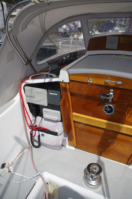
- A 9" Garmin Chart Plotter / MFD (replacing a 7" in the older pictures here) with Garmin vector charts that also displays AIS and Radar, overlaid on the chart or separately.
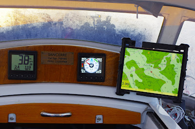
- A 10.5" iPad with GPS with a copy of the Garmin Charts plus "MemoryMap" with a full set of Admiralty raster charts of the UK and Ireland and the highly detailed The Antares Charts of west Scotland anchorages. I can mount this under the spray hood or keep it to hand so that it is easier to see the detail. MemoryMap is capable of displaying AIS but I did not bother replacing a failed NMEA2000 to wi-fi link to continue to do that. However it and the spare iPads can display and manage the Garmin Plotter or display what is showing on the PC navigation software.
- A PC on the Chart table with GPS and AIS from the Garmin AIS unit plus an independent GPS "dongle". This has the following software, all but the Navpro that requires a security dongle to be attached and only runs on a PC, use the same licence as the other units and can run concurrently, Nexus Race is a free download to run with Nexus equipment and the Garmin GND10:
- NavPro Navigation software with AIS, wind GRIBS, NavTex derived NM's and GMDSS weather forecasts displayed.
- MemoryMap and Antares charts as above, will display AIS but not when NavPro is doing so and requires a quick reconfiguration if needed to prevent clashes.
- Nexus Race that will display substantially everything the boats instruments can.
- An old iPad with GPS and a very old laptop / tablet PC as spares for the above. The iPads are operable at the same time as others under the licences.
- My iPhone that can do everything the iPads can do, albeit on a small screen.
- A very old iPad without GPS that can slave with the chart plotter, used occasionally on a mount above the chart table.
GPS is exceptionally reliable but things can go wrong most often with your system, for example loss of electrical power, equipment failure or operator error at a critical moment. Also when there is jamming or spoofing either illegally or by the military which should be notified in notices to mariners - when did you last check NM's (link works as at July 2025) after missing the often very early morning coastguard broadcast that includes them?Top TipBe prepared for GPS failure or large errors, it does happen and often without warning!
TipIf you suspect GPS or radar jamming that hasn't been advertised, call the Coast Guard - if it is NATO military and causing safety issues they can get it stopped.
 |
| Not long before the first outage I had been following a complicated route through islands, this section was well marked for the ferry, the earlier section wasn't. |
- 29th May 2023. At the north western end of the Sound of Harris on my way to St Kilda, GPS on my iPad disappeared for at least 5 minutes, the plotter lost signal momentarily but quickly got it back.
- 14th April 2025. When at anchor in Sanna Bay (Ardnamurchan) the anchor alarm went off, both the iPad and the plotter when it came on-line had errors of more than 50 yards. After 10 or 15 minutes reality restored itself and I had differential fixes accurate to a few yards.
- 26th & 27th June 2025. Dale Shelf, Milford Haven. Again anchor alarms, this time I did not switch on the plotter and the errors were not that prolonged but still several minutes each, they could have been a big problem if using only GPS to navigate a narrow passage.
TipRemember if GPS goes down, so may most if not all of the AIS functionality that relies on it.
Top TipsIf your application(s) has a "track" function, enable this for every trip, preferably on more than one device, then the unit(s) if still working should at least tell you where you where when things went pear shaped, but don't forget to cross check that from another source, especially if GPS accuracy is the problem as you may not know for certain when the problem started.It will be a easier to plot an E.P. if you enter positions in the log as a range and bearing from a fixed point, to transfer this to a paper chart or an electronic version is then only a single line with no messing around with a Lat and Long that is easy to mess up, earlier this year I was listening to a Pan Pan call from a fishing boat that was taking on water and the Lat and Long given to the Coastguard placed them off the Devon coast when they were a few miles south of Ardglass in Northern Ireland.
Radar
Top "colregs" Tips
In restricted visibility there is no "Stand on Vessel" for vessels not in sight of each other.
If you have radar and / or AIS you are required you to use it / them when in restricted visibility.
 |
| Making up to 10 knots in fog with 5 - 6 knots of tide helping. The chart uncluttered enough to have the radar in overlay mode on the 9" plotter. |
Unusually because of the strong tide I have the autopilot following a planned track (to less than a metre at this point) rather than following a compass course as I would normally when under engine, a compass course usually puts less stress on the autopilot and when crossing a tide is necessary to follow the shortest route.
At times like this it is reassuring to have active AIS so they (and VTS) knew I was there also to have radar and an AIS receiver so I could have gotten out of the way if they were filtering out Class B AIS and failed to see me on Radar.
Top Tip
Don't get so involved with electronic aids that you forget the MK I eyeball - look out of the boat when you can, it might surprise you what you can see between fog banks and pot buoys will probably not show on radar. Also the fog might have thinned whilst you were engrossed with the electronics.
The Garmin "Fantom" is a modern "Broadband" doppler solid state radar (technically a Frequency Modulated Continuous Wave Radar similar to those used for years by the military for tracking and guiding missiles) which uses less power than a conventional pulsed radar and brings some other significant advantages, especially the capability of working at extremely close range - a few yards - and the ability to detect moving targets. A downside is that broadband radars usually do not activate Racoon's or active radar reflectors both of which are looking for pulses.
Make sure you know how to use it, particulalry how to avoid the "radar controlled collision", go on a course, get a book, use it in good visibility to learn the ropes and possibly look for YouTube videos but do check the date it was written or made as radar has moved on and something written 15 or 20 years ago will be of very limited use. Also for You Tube or social media sources, check more than one to compare what they are saying.
MARPA (Mini Automatic Radar Plotting Aid) is in my view of limited use in a small boat as it frequently drops out with weak targets and the larger ones tend to have AIS which is more accurate. On larger yachts or in very calm seas it may be of more use as weak targets will show more consistently.
AIS
After radar the best anti collision aid available is AIS preferably a transceiver (they ARE NOT transponders!!!) to tell other people where you are, but a receiver only will do the job, with AIS equipped ships it is usually better than radar because of the longer range and lots of additional information. Some are stand alone (usually expensive) some work to a PC, inconvenient if the PC is below deck, some are integrated into the VHF with its own screen or, like a separate unit, they will integrate to the plotter and other devices.
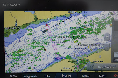
With a Multi Function Display such as a plotter and on some other screens it is usually possible to display a lot of information beside all targets on the screen but unless the screen is huge that will quickly clutter up the screen so much that it becomes unusable so it is normally best to display just the name of the vessel (for ease of identification) on active targets then click or tap on it to get the full story. Sometimes overload can happen with just the symbols:
Top Tips
There is usually an AIS alarm function to warn you of potentially dangerous targets. Use it! I once tracked a single handed sailor with AIS who presumably was asleep and almost collided with another yacht then blissfully carried on towards a collision with Berry Head. If I had not diverted to check up on him the Brixham Lifeboat would have been launched - they were already mustering, well before breakfast.
Also have the radio on at all times so the Coastguard can call you, if there is too much traffic (people asking for radio checks 😡) on C16 put it on a little used channel, they will try with DSC which will sound the alarm on the radio.
Ships can and do filter out all class B (small vessel) AIS returns when in very busy areas such as the Solent to declutter their screens, it has been known for them to forget to swich the filtering off when they are clear. If in doubt call them by name on VHF, another advantage of AIS is giving you that name and call sign.
Police, Boarder force, fishery protection and many naval ships, and those they may be hunting, often do not display themselves on AIS, but hopefully they will keep out of your way.
Ships have "class A" AIS and should be displaying their destination, although some forget or use codes you would need to look up. These can help in predicting where she is heading at long range, for example this year I picked up a ferry at very long range and confirmed straight away that, as AIS was telling me, in an hour it was going to be an issue as we would arrive at the Dublin Bay TSS at the same time, it might not have been if her destination was Belfast or Arklow both of which were possible. Ships should also advertise their navigational status, but quite often I see "moored" or "anchored" ships moving at speed miles from land. A drifting ship, something you see quite often when they can't be bothered to anchor will, usually show they are "underway using engine".
Just don't treat all AIS information as gospel and don't get hung up on vessels that show as being a problem an hour or two in the future.
Depth Finder.
An odd inclusion you might think and most boats will have one for the obvious reasons, but one not so obvious is if there are problems with GPS then it is a potential life saver when looking for a safe haven. In essence you aim for the coast some distance on a known side of your safe haven, the distance will be dependant on how sure you are of your position. Then when you reach a set depth contour (don't forget to reduce to soundings and to look for intermediate obstacles) you follow the contour home or to an identifiable point such as a buoy. Radar would be a big help used in conjunction with this technique.
The Cunliffe example in the video is something I have done more than once in in the same place on dark nights in pre-gps & yacht radar days; along the final run into Hurst castle you are safe a 100 yards off the beach often much closer, so you will usually be able to see land and often the lights of beach anglers.
 |
| Some more recent tracks through the north channel approaching Hurst Point 50 - 100 yards off the shore, no GPS required. |
Autopilot.
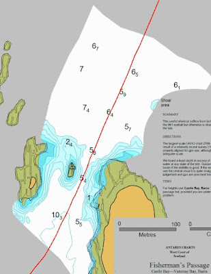 |
| I programmed this route in MemoryMap using the super accurate GPS chart, then transferred it to the plotter and went through on autopilot watching the progress like a hawk. The Admiralty chart showed me going over the central rock. The channel is 35 yards wide but looks less. Click here for more. |
A premium system like my Raymarine EVO Tiller Pilot will, like cheaper systems, steer to a compass heading but it will also sail to the apparent or true wind or too instructions from the chart plotter to follow a route using GPS. And it does not loose concentration, need comfort breaks or feeding except with Amp Hours and it rarely complains.
Close quarters Pilotage in Fog.
The following example is lifted from a detailed post on this years trip when unexpected fog rolled into Loch Aline when I wanted to get to Tobermory:
I was awake early after an early night to find a heavy mist, it had not been forecast and I suspected it was fairly local so decided to move off to get at least the first hour or two against a relatively slack tide. At 06:30 I could see both banks of the Loch, 5 minutes after I had got the anchor up everything had disappeared with the visibility perhaps 20 yards.
In shallow water it is prudent to have the anchor ready for instant lowering rather than stowed in a locker.
I was tempted to put the anchor back down but decided not to and gingerly went down the Loch at a walking pace, fortunately my modern doppler radar is particularly good close in with essentially no minimum range and at 100 meters (or less) will show just about everything, even reasonably sized pot markers in smooth water.
I had two independent DGPS's running and visible, one the 9" plotter with Garmin vector charts derived from the UKHO, the other a 10.5" iPad, fully charged and under power from the boat, it was displaying raster charts including the very accurate Antares GPS charts of the entrance and the anchorage (the lap top with Admiralty & Antares raster charts and different vector charts was not going to be much use as it is on the chart table).
As a bonus the plotter and iPad had tracks from previous visits (optionally displayed), my track inbound was my preferred one to follow as it was clear of lobster pots the day before and I displayed just that one on the iPad, see below.
 |
| A detail on the Admiralty Chart showing when areas were last surveyed, the resolution and how. All admiralty charts show this information Imray and electronic vector charts generally don't. |
In fog the Split screen mode is usually better than radar overlaid on the chart as weak radar returns are not hidden by chart detail, past tracks etc.. Also the radar view can be set for short range targets and the chart view for longer range for situational awareness and more distant AIS targets.
Approaching the loch entrance, the red blob ahead of me is the port lateral buoy, about 150 yards away, I saw it at 50 as the fog lifted. With a good rise of tide I could be sure of not running aground if I stayed within the previous tracks some of which were at low water.
The AIS contact at the top of the radar screen "Lara of Chichester" is, as I write, one berth down from me at Tobermory. She had left her AIS on whilst parked and arrived there in the early evening.
 |
| The ferry on her berth, about 75 yards away with the fog lifting further. |
.JPG)




No comments:
Post a Comment