Thursday, May 11, 2023

2023 May 8th, Day 24 Ballyholme Bay to Browns Bay (Larne)

Light and very variable winds turning to nothing before I cleared Belfast Loch then returning at F4-5 an hour south of Browns Bay so I called it a day, I might have gone further but residual waves from the SE might have made the anchorages further north, that I have not visited uncomfortable. Islay tomorrow.

White Cloud in Browns Bay, last seen at Milford.

14 miles in four and a quarter hours. 

2023 Bangor to Browns Bay

Click here for the trip to Islay.

Sunday, May 7, 2023

2023 May 6, Days 22 & 23 Howth to Ballyholme Bay, Bangor.

On Friday forecasts were still equivocal with F7 in one of them for Sunday so I decided on a dash to Bangor on Saturday with the option of anchoring in Ballyholme Bay, as good an anchorage as you are likely to find along this coast in a strong southerly or going into Bangor Marina. 

Its a long way with complicated tides (explained here, opening in a new window) and I was recommended not to leave an hour either side of low water because of shallows in the fairway to the marina, having seen the area round the pontoons at low water I added on half an hour so that that there would be 1.8 metres (the boats draft rounded up) of water above chart datum if in the dark I went a little outside of the dredged area I would still be floating. So departure was set for 03:45, in the event I left 10 minutes early, did a 3 point turn to head out and was on my way,

Lambay Island from Seaward, previously I have always gone
the other side.
Some wind set in a little after 05:00 and the cruising chute went up in 11 knots from the SSE which was to be pretty steady until 14:00 when it died and the engine went on so that I would past Strangford before the tied turned foul.

At 10:15 the wind lightened to 8 knots and  went round to the SE so up went the spinnaker, typically 45 minutes later and before I had put the camera away from taking the above video, the wind returned to the SSE so the cruising chute went back up to replace it.
With 5 knots of wind or less the engine stayed on and I reached Donaghadee Sound  a couple of hours ahead of schedule, with very light winds and a "smooth" sea I decided to press on through even though it was only a day before springs which would have 2.8 knots of adverse tide in the narrow channel with over-falls and a bit more further north, both predictions that the Admiralties "Total Tide" app nailed. 

In the event the passage was uneventful but interesting with rapidly changing tidal flows, especially entering Donaghadee Sound going from a back eddy running northerly at 1.5 knots to a southerly flow at over 2 knots in a couple of boat lengths.

Once through the narrows the engine went off at 19:30 and I anchored at Ballyholme Bay, just east of Bangor at 22:10. 

90 miles in 19 hours.

The forecasts are still inconsistent with each other but all have dialled back on the F7 (Edit: the F7 reappeared in the mid day forecast on Sunday) and it should be possible to move north on Monday afternoons ebb tide to get into position to strike out for Islay or Ghia on Tuesday or Wednesday before the wind turns northerly. 

Update: I have (Sunday morning) given up thinking about that and will work out a plan when I see the forecasts tomorrow morning. In the mean time the flat calm this morning has been replaced with a fresh southerly wind that promises to get stronger overnight with the possibility of thunder storms tomorrow.

Approaching Donaghadee.
Ballyholme Bay (Bangor) Sunday morning.
Also Sunday morning: the ship at anchor had been clearly visible
5 minutes previously as this fog bank appeared from nowhere
A ferry coming down Belfast Loch entering the new fog bank,
it is likely that a small yacht ahead would not be visible from
the bridge, radar and AIS on both sides makes a huge difference.

2023 Wiklow - Bangor

Thursday, May 4, 2023

2023 May 2nd, Days 18 - 21 Wicklow to Howth.

Another change of plan due to the weather, I had planned to go to the Skerries today (Tuesday) and Ardglass tomorrow to shelter from strong easterly or south easterly winds arriving Thursday evening but the system is arriving early (and much earlier than forecast a few days ago) and that makes entry to Ardglass problematic, even dangerous, even before the strongest winds arrive.

I didn’t want to be at anchor at the Skerries which would be uncomfortable in an easterly and possibly untenable if the wind was north of east so I will divert to Howth, just north of Dublin, which is safe from winds from any direction. I’ll probably be here until Friday but a move to an anchorage might be practical late Thursday.

The view from my berth on the hammerhead, the island known
as Ireland's Eye in the distance.
The rebuilt breakwater protecting the marina, the Pilot says
this was broken down and at best awash at HW.
The view back to the huge club house.
Thursday mid day and the wind was still increasing. If I had
continued to Ardglass I would be arriving in stronger winds
blowing straight down a narrower channel than this. 
Spray from waves breaking on the other side of the island
sometimes went higher than the Martello tower, this pic was
taken about half an hour before the yacht in the next pic arrived.
If going for shelter in Howth in a strong wind from the east you
need to get there before it arrives, although it should be doable,
this boat was coming from Malahide and through Howth Sound
rather than from the east, south of Ireland's Eye.
The view out to sea from the club house.

26 miles in five and a quarter hours.

Thursday, day 20:

Ideally I would leave tomorrow at  04:30 to Dundalk Bay or Ardglass then on to Bangor then Larne but looking at the models downloaded this morning I suspect I’ll not get way until later in the day and will do a short hop to the Skerries for Friday night then head north on Saturday, possibly going direct to Bangor, if I leave at 04:30 and can make 4 knots I can get to the tidal gate at Donaghadee as the tide turns favourable at 23:00 on Saturday and into Bangor a couple of hours later to anchor or if the weather looks threatening to go into the marina later on Sunday.

However Ardglass is a distinct possibility for Saturday night  as the tides are then good to get from there through the Sound at the end of a N going tide on Sunday afternoon.

The American model is showing very strong winds early on Monday, the others show brisk to strong winds, either way I need to plan to be somewhere secure on Sunday.

I’ll have to make decisions every 12 hours when I get the detailed models to supplement the met office forecasts . 

Friday a.m. day 21:

Thursday's plan didn't survive very long, three models downloaded at 08:30 show winds at the Skerries gusting 25 to 30 knots so I'll be here another night, or at least part thereof, this mornings plan is to leave about 03:30 on Saturday morning (there is insufficient water for me to leave between 05:00 and 07:00 and I would like bit in hand), accepting a couple of hours of foul tide, heading either for Ardglass or more likely, if the wind holds (the ECMWF says it will the UKMO says it will not), direct to Bangor. Strong winds  are likely to be arriving late Sunday so if I don't get to Bangor on Saturday night I may be at Ardglass until Tuesday.
2023 Howth
Click on the pic above for an expanded view in Flickr, otherwise click
on the arrows to view the slide show.

2023 May 1st, Day 17 Carnsore to Wicklow

10 hours of very good sailing reaching in F3-4 occasionally 5, then the W - NW wind died and switched to the east so on went the iron topsail c 6 miles short of Wicklow head fighting 1.7 knots of tide.

The north side of  Wicklow Head.

Wicklow and the Harbour.
Not so attractive in the other direction.


52 miles in 12 hours and 450 miles from the Hamble.

2023 April 30th, Day 16 Milford to Carnsore

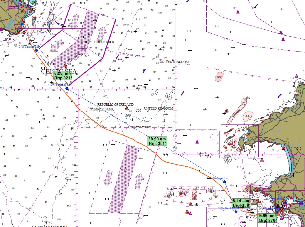
I left at 0515, an hour late as the alarm did not sound - my new iPad had sound for the alarm turned off by default which is a bit strange. The visibility was very variable and mainly between 2 and 5 cables, I motored for a couple of hours into a nasty sea until I was clear of the entrance and Skokholm Island and except for one burst of engine to avoid a ship I was able to sail until reaching the offing for St Margret's bay, Carnsore point, most of it in dank misty weather in F3 winds increasing to F4-5  by mid afternoon.

At the north end of the "Off Smalls" TSS. The blue blob over
the ship WSW of me is the radar return from a big ship at 3.5 NM.
The ship Sanskip Endeavour was coming up the north bound lane of the TSS at 16.5 knts and according to AIS would be very close in fog, at the same time Elizabeth K?? was coming south IIRC at 7 knts also projected to be close. Although making better than 5 knts under sail I put the engine on for a while making better than 7 knots which is over the theoretical max hull speed. Naturally as soon as I had cleared her projected path Sanskip slowed to 9 knots, I assume when entering the fog, and I cleared her by miles then went behind Elizabeth, seeing neither except on AIS and on Radar.

The last  2 or 3 hours was excellent sailing in warm sun and good visibility.

Carnsore Point is low lying and difficult to see and in the days
before GPS it would be very easy to get down tide and end up
fighting a couple of knots of tide. Apart from GPS the wind
turbines make a good radar target and are easier to see.
 (click on the pic to see for yourself).
Getting close.
Milford to St Margret's Bay, Carnsore Pt.

61 miles in twelve and a quarter hours.

Wednesday, May 3, 2023

2023 April 28th, Day 14 & 15 Newlyn to Milford Haven

A bumpy start motoring directly into wind and waves to the Runnel Stone, ideally I would have left at about 02:00 for the best tide around Lands End but I compromised to get more sleep and left at 04:45 which would allow me to clear Cape Cornwall before the tide turned and would also allow a bit more time for the wind and waves to moderate.

With contradictory forecasts from different models, I left not knowing if I would be heading direct to Ireland, to Milford Haven, to St Ives or further up the Cornish or Devon coast, that was resolved when I downloaded multiple models at 08:40, had the inshore and shipping forecast from the UK Met office and the forecast from Met Eireann. St Ives would likely be too exposed to waves and a poor starting point going NW, Carnsore was a long way off in light winds and would require much more motoring so I decided on Milford.

A few large sets where coming through as I passed The Longships
but now it was reasonably comfortable as I was not bashing directly
into the waves.
The engine went off at 08:00 and I was sailing on a reach in a WNW Force 3 - 4, after 3 hours the wind backed to WSW at 3 - 5 knots and the engine went on for a couple of hours until the wind had backed further to SW and increased back to F3 - 4 so at 13:30 the engine went off and I was making good progress with the cruising chute.

From mid afternoon mist turned to fog and by late afternoon visibility was some times down to less than a quarter of a mile. The engine had to go on again at 18:18 when the wind had dropped to 4 - 7 knots and stayed that way for the rest of the night. 
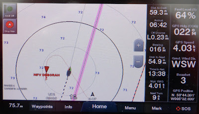
Sailing in fog is always tense, even with radar and AIS to help.
Here the Irish fishing boat went right around me unseen as I went
N making 5.5 Knts through the water, 4 over the ground.
 The first “Range Ring" is half a mile from the boat.
The fog got gradually worse and by Turbot Bank, 3 miles short of  the entrance to Milford Haven, the visibility was down to well less than a cable (200 yards) and I was navigating with 2 independent GPS systems and charts (the plotter and an iPad with Admiralty charts) and Radar. 

Milford Haven VTS (Vessel Traffic Service) called at that time with traffic information, a request for current visibility at my location and to ask for my intentions as a ferry was outbound, fortunately using the west channel whilst I was using the east but it was another thing to keep an eye on with Radar and AIS.

I was spending a lot of time watching the radar, and paying the price with a "crick" in the neck as I could pick up the buoys at a mile or more on radar but only at 1 and later 2 cables visually - and these are big well lit buoys to help the big tankers going in and out.

I anchored on Dale Shelf at 04:15 for a few hours sleep and a rest day before heading for Ireland.
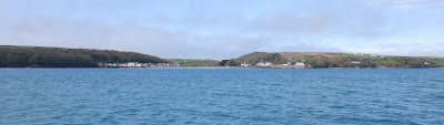
Dale

The big French catamaran on the right left Newlyn 8 hours after
me but despite having a foul tide around Lands End arrived
only 1.5 hours after me.  

A quick passage with a lot of engine and some quick sailing, 119 nautical miles in 23.5 hours.

Canadian yacht White Cloud, we would meet again, more than once.
Click here for Milford to Ireland.