The forecast was mixed with models not really agreeing in the detail but there looked to be an opportunity to get to St Mawes which would, with the tides, make it much easier to get to Newlyn.
There was virtually no wind in the Fowey river as it is well sheltered from the east so, I started monitoring the local weather stations, many are not well placed to accurately monitor an easterly being themselves sheltered, Prawel Point (Salcombe) consistently was showing a very high number probably because the station is at the National Coast-watch Institutes (NCI) lookout on the top of the high hill. NCI Nare Point, just south of the Helford, was a better bet.
 |
| Actual wind speeds displayed in Predict Wind, updated every 30 minutes, slightly delayed. |

As can be seen the wind started to moderate at about 07:30, I would preferably leave between 10:00 and 11:30 to stand a chance of get into the Fal before the tide turned adverse shortly after 15:00 but I wanted to see a continuing trend so I waited for the 12:00 update that showed sustained winds of 13 knots gusting to 20 which would be fine, especially off the wind, so I was quickly away.
 |
| Leaving Fowey under the heavy weather jib the stay would need to be tighter going up wind, I had not taken is back to a winch. |
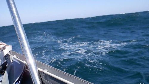
The heavy sea could lead to the boat surfing, which is fun and quick but potentially dangerous as it can easily lead to a broach - a sharp turn in either direction that that can knock the boat down or in extreme cases roll the boat right over to inverted, inversion was very unlikely to happen with waves I was seeing but a broach is violent and to be avoided.
The best way of doing that is to sail slower than the waves, fortunately I had chosen to use the 12 sq metre heavy weather jib and no mainsail which achieved that but, with the need to keep well off the lea shore and the heavy sea, it did mean the tide changed to about 1 knot adverse when I was a couple of miles short of St Anthony Head that guards the Fal. The sea then became horrendous with very steep 2 metre waves sometimes very close together. Naturally the wind piped up (reinforced by the tide change adding 2 or 3 knots to the apparent wind).
Throw into that a lot of poorly marked lobster pots 3 of which I had to change course to just avoid and I was not happy. As I posted on Facebook, using a favoured terminology of aeroplane pilots:
[The] trip varying from smooth to “sporting” and at times “character forming” but did not reach “brown trousers”
but it was close.
Relatively smooth going at slack tide between Dodman and St Anthony Head, I was far to busy to try and take another in the rough water.
Getting the anchor down was easy once I had dropped the heavy weather jib, the wind blowing the boat back to set the anchor immediately, then half an hour later the wind was down to about 10 knots and later I was sitting out in the cockpit.

22 GPS miles in four and a half hours.
No comments:
Post a Comment