Thursday, May 20, 2021

2021 Round GB Day 30. Loch Eriboll to Loch Ned

This was another leg requiring good weather and timing to avoid rough seas off of Cape Wrath, as last year I was quite lucky with reasonable weather and a sensible start time to make Cape Wrath at slack water (c 13:00) before the south going tide would help me down the west coast. Strangely enough Cape Wrath is not named for wrathful seas but is derived from old Norse for "turning point".

It was a day of three parts.

Motoring I could have reached the Cape with a later start but preferring to sail as much as possible I was off at  08:30, after the almost obligatory motoring part up the loch I caught a reasonable breeze and used it reach well out to sea to hopefully keep clear of rougher seas off the Cape and to make better speed.

I had two routes planned, one offshore for heavy weather (shown)
and one inshore for good weather, in the event I split the
difference, starting offshore due to the sea state then coming
inshore for the run down the west coast.
Leaving Loch Eriboll
The wind did not last and in the second phase of the trip the engine had to come on for a couple of hours to north of the Cape by which time it was clear that the seas were not as bad as feared and conveniently the wind  came up to around 14 knots from the north east and I was off reaching under headsail only at good speed. "Flying Fox" that had shared the anchorage at Eriboll almost caught up to me at the cape but then headed offshore towards the Outer Hebrides.

Biggish but not excessive seas coming into Cape Wrath.
(Big seas rarely look as big in pictures!)
Coming into Loch Ned there was an unwelcome announcement by Stornoway Coastguard that a GPS jamming exercise would shortly start as part of a huge NATO event and I was 5 miles inside the area that could be effected. And just as I would be looking for the entrance to the loch which is not that easy to spot. 
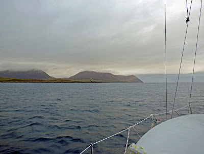
Meall Mor, three miles from Loch Ned, the entrance to which
is just to the right of the island.
Less than a mile to run and its still tricky to see the entrance
even with binoculars.
Fortunately I was navigating boats well before GPS was even a twinkle in the eye of the US Dept. of Defence and I still carry lots of paper charts. The chart plotter and iPads would display charts without GPS but its much easier to get your bearings with a large scale chart, in this case a 1:25,000 chart of Eddrachillis Bay. As things turned out my GPS was unaffected but GPS spoofing (introducing positional errors rather than jamming) can be subtle so caution was needed even with good visibility. 

Less than half a mile out, the entrance is just to the right of the
shroud and above the guard rail stanchion.
Entering Loch Ned
Looking out from Loch Ned pictured in 2020.
Seals basking on an islet at the top of the Loch. 

48.5 miles over the ground in 11.5 hours.

Slide show all of my pictures from Loch Eriboll to Loch Ned, page through by clicking the arrows or click in the centre of the pic to view from Flickr in a new window or full screen:

2021 Loch Eriboll - Loch Ned


2021 Round GB Day 29. Stromness to Loch Eriboll.

Approaching Hoy Sound from Stromness
  
A very quite Hoy Sound, things would
be different in an hour or so later.
The best passage out of Scarpa to the west is via Hoy Sound, conveniently located near Stromness, there is however a catch, as the Clyde Cruising Club's pilot notes:

"The tidal streams in Hoy Sound are very strong (8 knots [with over-falls]) and entry should not be attempted in bad weather, nor with wind against tide, nor on the west going tide. Accurate timing is necessary to ensure favourable wind and tidal conditions"

The good news is that the west passage can be made at slack water so I slipped at 05:15 in time to catch the last half hour of  the west going tide and I was able  to motor the couple of miles through the danger area in very benign conditions.

Some wind started to fill in as I passed out of the sound and by 09:00 it was blowing at 17 knots, again from directly astern which, although far preferable than directly ahead, can be very uncomfortable with the boat rolling and on this occasion with the waves coming from the north and abeam made it difficult to steer. 

Achilles 9 metres Sancerre in Hoy Sound, Orkney
Hoy from Hoy Sound.
The NW corner of Hoy
The 500 ft high "Old Man of Hoy", the cliffs are about double that.


Interestingly the simple wind vane steering did a much better job than the high tech autopilot as the latter kept trying to adjust to the sea state and the wind (it has motion sensors and attempts to learn a pattern as well as being reactive), whereas the wind vane steering just keeps the boat as far as possible at a constant angle to the apparent wind and the boat looked after herself with respect to the waves. The wind vane is also quite - the autopilot working hard is very annoying  and uses a lot of electricity. 
Disturbed sea NW of Hoy
The wind dropped during the day and for a couple of hours in the early afternoon I had to use the engine as the boat was rolling so much that the sail - I was using just the head sail - was just crashing about. I arrived off Loch Eriboll shortly before 17:00 and motored for an hour up the loch to the anchorage at Ard Neackie.
Ard Neackie Anchorage, North Side.

I was joined shortly after arrival by the 36ft "Flying Fox",
we would meet again

The "Ard Neackie" anchorages, in Gaelic "ard" means
high or lofty so perhaps this translates to "high neck".
A not very straight course from Hoy Sound to Eriboll due
to the changing wind and choppy sea. 

55.5 miles over the ground in twelve and three-quarter hours.

Slide show all of my pictures from Stromness to Loch Eriboll, page through by clicking the arrows or click in the centre of the pic to view from Flickr in a new window or full screen:

2021 Stromness - Loch Eriboll

Click here for day 30, Loch Eriboll to Loch Ned. 

Wednesday, May 12, 2021

2021 Round GB Days 27 & 28. Hunda Sound to Stromness.

At last a warm day! Unfortunately the wind was very light, most of the time only about 5 knots but it was a pleasant sail and for the first time on this trip I was sailing in shirt sleeves and shorts - at least for a few hours.

Track from Hunda Sound to Stromness. Skirting the
Barrel of Butter reef at the half way point.
The "Barrel of Butter" reef with Hoy and Fara behind.
The boat has divers down, probably fishing for Scallops, the owner
dived on Sancerre last year when I had propeller problems
A nice Laurent Giles 38 footer also going to Stromness, I was the
first visiting yacht at Stromness this year half an hour ahead of her.
Defences on the Orkney "mainland" shore of Scarpa Flow.
Graemsay and Hoy
Stromness

Some interesting trivia (for many) we are still well off the longest day but the almanac includes this for Stromness: 

21:31  Sun Set azimuth 309°
00:20  End of Nautical Twilight azimuth 348°
01:58  Start of Nautical Twilight azimuth 012°
03:49  Start of Civil Twilight azimuth 038°
04:46  Sun Rise azimuth 050°

Looking from Stromness towards Scarpa Flow.
Today (Wednesday) its back to normal with a fairly strong cold wind, a bit of rain and no sun. The forecast is reasonable (NE F3-5 backing N in the afternoon or evening, with showers) to get to Loch Eriboll tomorrow although its likely to be uncomfortable, another dead run, and probably a nasty sea although the forecast says the waves will be "slight to moderate".

13.7 miles in less than 5 hours.

Slide show of all my pictures from Peterhead to Stromness, page through by clicking the arrows or click in the centre of the pic to view from Flickr in a new window or full screen:

2021 Peterhead - Stromness

Monday, May 10, 2021

2021 Round GB Days 25 - 26. Peterhead to Hunda Sound (Orkney).

Sailing with the cruising chute, its about 45 square
metres, half as big again as the already large genoa.
The day started with light winds and quite big waves from previous high winds, I slipped at 06:00 and motored north until 09:00 when some wind got up. Unfortunately it was almost dead astern, with a "sloppy" sea and the prospect of more wind to come I started with just the headsail but quickly changed to the larger cruising chute.

Sailing with just the cruising chute and no mainsail allows it to work on a dead run, with the mainsail up it collapses. The alternate is to fly the chute or the symmetrical spinnaker from the pole but setting that was too much like hard work and with variable winds and a choppy sea was unlikely to generate a lot more speed as I was already making 5 - 6 knots and only needed 4 knots or a little more to make the tidal gate to enter the Pentland Firth.

The wind finally settled to a nice force 4 from the south east and I made good progress, there was even some sun! And whilst it wasn't particularly warm it wasn't cold and I went until evening with warm feet 😀 

For a while I even took a lead from sailors in the trade winds with two headsails, or in my case the cruising chute and genoa which makes the best of a dead run, never a happy point of sailing, without the bother of a spinnaker which would have been a bit of a hand full in the prevailing conditions. It also means you don't have the mainsail flapping about and wanting to gybe and with all of the power in front of the mast it makes the boat more stable, a bit like having front wheel drive and not having the power on the back wheels and the weight further back trying to flip you round - and in the case of the old Porsche 911s frequently succeeding! The down side is that the cruising chute can't be dropped behind the mainsail so care is needed even with the snuffer, in an emergency it would be gybed onto the genoa before lowering.

A variant of the classic two headsail approach to the dead run.
Cruising chute on one side, 150% genoa on the other and
both drawing nicely. If using this configuration the Genoa should
be held out with the spinnaker pole for better stability.
Making 4.9 knots in 10 knots of wind. It would be 5.5 - 6 knots
with the mainsail and 60 square metre symmetrical spinnaker
but this configuration is a lot easier to handle in gusty conditions.

Crossing the Pentland Firth:

Tides run strong though the Firth, even out of races they are often faster than many yachts can run under engine, Sancerre has more than twice the power originally specified and can move somewhat above the maximum theoretical hull speed of 6.8 knots, and that is not sufficient to stem the flow even before it really gets going. Timing is therefore critical, to get to Scapa flow from the south or south east the pilot recommends being 2 miles east of Duncansby Head 1 hour 15 minutes after High Water Dover as the tide changes and then to follow the planned track shown by the blue line on the chart below, that does not mean pointing the boat in that direction, at the best of times the current will push you away so you go across crab wise.

The squiggly lines are tidal races, all dangerous to small boats
and some to large ships as well. The Admiralty chart says
that 16 knot currents have been reported close west of the
Pentland Skerries, a few hundred yards east of the planned track.
This part of the Firth is quite confined the gap between  Swona
and Barth Head is 1.5 miles, much of which is not navigable
due to the race on the west side.

I was  about 2 hours ahead of schedule at 19:00 when the wind died so to be on the safe side I used the engine to get further ahead of plan heading for Duncansby, after a couple of hours the problems started as the adverse tide was far stronger than estimated and this worsened the already awkward sea steep, often breaking, 2 - 3 metre waves. 

Finally I almost came to a halt 5 miles short of the off Duncansby Head waypoint despite making over 6 knows through the water and sometimes surfing the big waves at 7.5 knots. This stretch of water does not have any tidal prediction Diamonds, severe tides are not mentioned in the pilot and it was mid way before neap and spring tides so it is likely that part of the problem was weather systems to the West, NE and SE. Certainly the tide was late as it was against about an hour after it should have turned, at least the tides within the Firth would also be delayed.

I was well over an hour late vs plan passing the Pentland Skerries and moving at over 6 knots in calm water the autopilot was steering more than 45 degrees above the desired track to stay on it. Passing the Lother Rock the tide was running at over 6 knots and to make progress I allowed her to fall off 30 degrees for a short while to get out of the east-west channel, if I had been any later and the tide correspondingly stronger I would have had to bail out going well south of Swona and the dangerous race on its south side.

And just to make life more interesting two merchant ships were moving west through the Firth and one moving east all crossed less than a mile ahead of me and one about a quarter of a mile, not a major problem with AIS (Automatic Identification System) and Radar, and particularly at night when ship's lights make judging angles and relative movement easier, but it certainly kept me busy.
My track through the Firth.
It was now well past 02:00 so I went on to Hunda Sound for the rest of the night.

Hunda Sound on the south side of Scarpa Flow looking NE
at 04:00 after I had anchored and shut everything down.
I was unable to contact Stromness marina until late Monday morning by which time the weather was looking iffy with a strong wind and rain promised for this afternoon so I will be staying here tonight and will move on tomorrow.

98 nautical miles over the ground, and more - about 117 - through the water, in 22 hours.

Sunday, May 2, 2021

2021 Round GB Days 16 & 17. Holy Island to Peterhead

After the delayed start described in the previous post I went out with a bit more tide than anticipated, not significant in the channel or over the bar, but it was further out with some a fairly rough sea, especially during the first couple of miles until I made my offing, I delayed hoisting sail until then rather than work on a seriously bucking and rolling deck.

The SeaFeather self steering gear doing its job beating
to windward in a F5 wind leaving Lindisfarne.

The weather forecast caused some confusion, the one I had when I left said that the wind would back round to the NW so I headed off to the west of the rhumb line.

My track out of Lindisfarne.
Then the next forecast said it would be NE so I put in a tack, that lasted for about 4.5 uncomfortable miles with the waves slowing the boat so I tacked back and boat speed over the ground almost doubled.

The wind died after about 35 miles and became variable for the next 45 and I was largely motor sailing before the wind set in from the NW and I was able to sail up past Aberdeen until 3 or 4 mile short of Peterhead when the wind died again so, being very cold and not wanting to hang about, I put on the engine and made my way into Peterhead marina arriving after 28.5 hours and 186 miles over the ground.

Peterhead Marina. Sancerre on the furthest pontoon with a
fairly long zig-zag walk to get there.

The prognoses for getting to Stromness was not good with variable but largely light headwinds, stronger winds then expected on Monday and very strong ones shortly afterwards. Forecasts on Sunday morning would be the deciding factor.

Two routes to Orkney, direct and via Wick,
the later needing a diversion to pass an
under construction extension to the
windfarm
On Sunday morning after a lot of sleep I checked out the forecast which was still equivocal with 5 models giving slightly different results for the waters south of Orkney, the complicating factor was that to make a safe passage into Scarpa on Monday morning I had to be off 2 miles off Duncansby Head (the NE point of Scotland and still a good distance from Stromness) at 05:35 or shortly after, if not then the next "gate" opened at 17:50. And the bad weather would probably start to arrive early evening on Monday, a rather risky situation which with light headwinds would likely mean motoring all the way, but at least I could change to option two.

The second option was to move to Wick and wait out the bad weather there, that could easily be done in the time available, at least with a lot of motoring, but I decided to wait it out in Peterhead, the clincher was a forecast low air temperature of just 2 degrees C and another full night at that temperature was not something I was keen to do.

The forecast for the next week or two indicates it could be a good while before I get to Stromness, the models are changing frequently but from the 08:00 downloads on Sunday the earliest I will be able to leave is Thursday but I suspect Friday is more likely, perhaps with a stop off in Wick to catch a weather window. Then according to some models there is more bad weather coming.
Blustery weather at Peterhead
Achilles 9 metres Sancerre at Peterhead

There were no facilities open in the marina but at least it was an easier walk into town than at Blyth and better shops with a good Morrisons supermarket (with open toilets) and a laundrette where I had all my laundry washed dried and appropriate pieces ironed, the later being something of a luxury whilst cruising.
The walk around the harbour returning from town.

Update:

The weather did not cooperate and it was not until Sunday 9th that there was a window long enough to risk the passage.....

2021 Round GB Day 16. Problems with a couple of anchors

I was all ready to leave at 05:30, then I tried to raise the anchor and couldn't. After motoring round the anchor I finally broke it out but then the windlass had problems lifting it, with a bit of help I got it close to the surface and saw the trouble - another anchor, that is not uncommon in a crowded anchorage and is usually relatively straight forward to sort out but I was the only boat in the anchorage and it became clear that this anchor was not your standard modern yacht anchor coming from a much heavier vessel. 

Initially I could not get either anchor above water but I got a line round it and used the Handy Billy (a block and tackle with snap shackles at each end and a built in jammer) from the pulpit to hoist some of it within reach, this is what I saw:

My 10 Kg / 22 Lb modern anchor with its chain
wrapped around an ancient "Fisherman" type anchor
probably weighing well north of 100 Lb., certainly
more than I could lift without the benefit of the
handy billy.
Now drifting with the tide which would shortly be running at 2 knots I motored slowly over to to the fisherman's moorings, hoping the anchor would not crash into the bow, and borrowed one whilst I sorted things out.

With the weight of the rogue anchor taken by the pulpit letting out chain allowed me to unwrap some chain and get my anchor on board and disconnected from the chain. I had hoped that without the anchor on I might be able to unwrap my chain by hanging over the bow and with deft use of the boat hook. Unfortunately I couldn't, it was too tightly wrapped on the anchor stock well under water,

I did consider getting into the water but even with the wet suit it would have been very cold work and I did not fancy being in the water next to a large anchor swinging around, drying out against the quay was a possibility but without knowing the state of the sea bed rather dodgy with a fin keeled boat - it could fall over or more likely forward or aft potentially damaging the rudder. 

The rogue anchor with as much chain removed as I
could manage, note the long cross pieces under water
with chain still wrapped around it.

So out came the hacksaw and I cut off about 15 meters (update: actually 18 metres) of my 50 metre anchor chain, I have 40 metres of nylon line attached which has never been used so I still have a working anchoring system with the windlass and in dire straights I have a couple of kedge anchors, including a 24 Lb CQR and 80 metres of very strong 14mm platted nylon.

With everything sorted as well as I was able, I motored away from the mooring and cut the rogue anchor free in deeper water where no one is likely to want to anchor.

Last year at Holy Island I anchored through a car tyre so its not the cleanest of anchorages.

Click here for the rest of the trip.